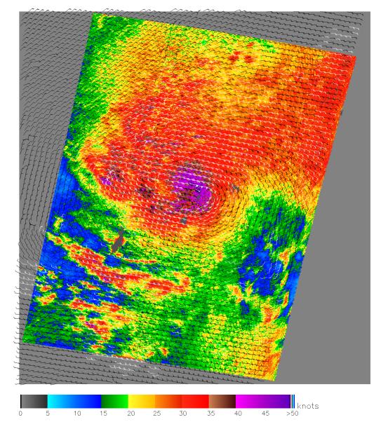
1 Dec. 2004
This image, produced from data collected by the SeaWinds scatterometer instrument onboard NASA's QuikScat mission reveals the details of the surface winds and rain in Typhoon Nanmadol as it moves westward. The data was collected on 1 Dec. 2004 at approximately 8 in the morning.
SeaWinds uses radar to peer through clouds and darkness to measure the near-surface wind speed over the ocean on a daily global basis. In this image of Typhoon Nanmadol, ocean wind speed is shown in color with wind barbs showing the wind direction. The Typhoon eye is visible as a brown patch within the purple area of most intense wind speeds (50+ knots) and rain. The red area of high winds (30+ knots) extends over 800 km around the eye. The grey area in the center left is the Island of Yap. The typhoon is moving about 28 mph to the west-northwest and is gathering strength before it hits the Phillipines a few days later, leading to 1000 casulties according to Reuters.
In recent years, the ability to detect and track severe storms has been dramatically enhanced by the advent of weather satellites. Data from the SeaWinds scatterometer is augmenting traditional satellite images of clouds by providing direct measurements of surface winds to compare with the observed cloud patterns in an effort to better determine a hurricane's location, direction, structure, and strength. Specifically, these wind data are helping meteorologists to more accurately identify the extent of gale-force winds associated with a storm, while supplying inputs to numerical models that provide advanced warning of high waves and flooding.
QuikScat Background
NASA's Quick Scatterometer (QuikScat) spacecraft was launched from Vandenberg Air Force Base, California on June 19, 1999. QuikScat carriesthe SeaWinds scatterometer, a specialized microwave radar that measures near-surface wind speed and direction under all weather and cloud conditions over the Earth's oceans. More information about the QuikScat mission and observations is available at http://winds.jpl.nasa.gov. QuikScat is managed for NASA's Science Mission Directorate, Washington, DC, by NASA's Jet Propulsion Laboratory, Pasadena, CA. JPL also built the SeaWinds radar instrument and is providing ground science processing systems. NASA's Goddard Space Flight Center, Greenbelt, MD, managed development of the satellite, designed and built by Ball Aerospace & Technologies Corp., Boulder, CO. The National Oceanic and Atmospheric Administration has contributed support to ground systems processing and related activities.