PDS logoPlanetary Data System
PDS Information
Find a Node - Use these links to navigate to any of the 8 publicly accessible PDS Nodes.

This bar indicates that you are within the PDS enterprise which includes 6 science discipline nodes and 2 support nodes which are overseen by the Project Management Office at NASA's Goddard Space Flight Center (GSFC). Each node is led by an expert in the subject discipline, supported by an advisory group of other practitioners of that discipline, and subject to selection and approval under a regular NASA Research Announcement.
Click here to return to the Photojournal Home Page Click here to view a list of Photojournal Image Galleries Photojournal_inner_header
Latest Images  |  Spacecraft & Technology  |  Animations  |  Space Images App  |  Feedback  |  Photojournal Search  

PIA06992: Radar Shows Titan Live and in Color
 Target Name:  Titan
 Is a satellite of:  Saturn
 Mission:  Cassini-Huygens
 Spacecraft:  Cassini Orbiter
 Instrument:  Radar Mapper
 Product Size:  1846 x 1882 pixels (w x h)
 Produced By:  JPL
 Full-Res TIFF:  PIA06992.tif (8.428 MB)
 Full-Res JPEG:  PIA06992.jpg (1.142 MB)

Click on the image above to download a moderately sized image in JPEG format (possibly reduced in size from original)

Original Caption Released with Image:

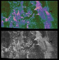
Saturn's moon Titan shows a sharp contrast between its smooth and rough edges in a new false-color radar image.

To provide a better perspective of the surface features, the color image is shown alongside a black and white image that was previously released. To read the full caption for the black and white image click here PIA06988.

In the new color image, brighter areas may correspond to rougher terrains, slopes facing the radar, or different materials. The pink colors enhance smaller details on the surface, while the green color represents smoother areas. Winding linear features that cut across dark areas may be ridges or channels, although their nature is not yet understood. A large dark circular feature is seen at the western (top left) end of the image, but very few features on Titan resembling fresh impact craters are seen.

The area shown is in the northern hemisphere of Titan and is about 150 kilometers (93 miles) wide by 300 kilometers (186 miles) long. The image is a part of a larger strip created from data taken on Oct. 26, 2004, when the Cassini spacecraft flew approximately 1,200 kilometers (745 miles) above Titan's surface.

The Cassini-Huygens mission is a cooperative project of NASA, the European Space Agency and the Italian Space Agency. The Jet Propulsion Laboratory, a division of the California Institute of Technology in Pasadena, manages the Cassini-Huygens mission for NASA's Science Mission Directorate, Washington, D.C. The Cassini orbiter was designed, developed and assembled at JPL. The radar instrument team is based at JPL.

For more information about the Cassini-Huygens mission visit http://saturn.jpl.nasa.gov.

Image Credit:
NASA/JPL-Caltech/ASI

Image Addition Date:
2004-11-05