AnimationAbout the animation:
This simulated view of the potential effects of storm surge flooding on Galveston and portions of south Houston was generated with data from the Shuttle Radar Topography Mission. Although it is protected by a 17-foot sea wall against storm surges, flooding due to storm surges caused by major hurricanes remains a concern. The animation shows regions that, if unprotected, would be inundated with water. The animation depicts flooding in one-meter increments.
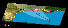
About the image:
The Gulf Coast from the Mississippi Delta through the Texas coast is shown in this satellite image from NASA's Moderate Resolution Imaging Spectroradiometer (MODIS) overlain with data from the Shuttle Radar Topography Mission (SRTM), and the predicted storm track for Hurricane Rita. The prediction from the National Weather Service was published Sept. 22 at 4 p.m. Central Time, and shows the expected track center in black with the lighter shaded area indicating the range of potential tracks the storm could take.
Low-lying terrain along the coast has been highlighted using the SRTM elevation data, with areas within 15 feet of sea level shown in red, and within 30 feet in yellow. These areas are more at risk for flooding and the destructive effects of storm surge and high waves.
Data used in this image were acquired by the Shuttle Radar Topography Mission aboard the Space Shuttle Endeavour, launched on Feb. 11, 2000. SRTM used the same radar instrument that comprised the Spaceborne Imaging Radar-C/X-Band Synthetic Aperture Radar (SIR-C/X-SAR) that flew twice on the Space Shuttle Endeavour in 1994. SRTM was designed to collect 3-D measurements of the Earth's surface. To collect the 3-D data, engineers added a 60-meter (approximately 200-foot) mast, installed additional C-band and X-band antennas, and improved tracking and navigation devices. The mission is a cooperative project between NASA, the National Geospatial-Intelligence Agency (NGA) of the U.S. Department of Defense and the German and Italian space agencies. It is managed by NASA's Jet Propulsion Laboratory, Pasadena, Calif., for NASA's Science Mission Directorate, Washington, D.C.
Location: 28 degrees North latitude, 23.5 degrees West longitude
Orientation: North toward the top
Size:890 by 1447 kilometers (552 by 897 miles)
Image Data: MODIS image and colored SRTM elevation model
Date Acquired: February 2000

