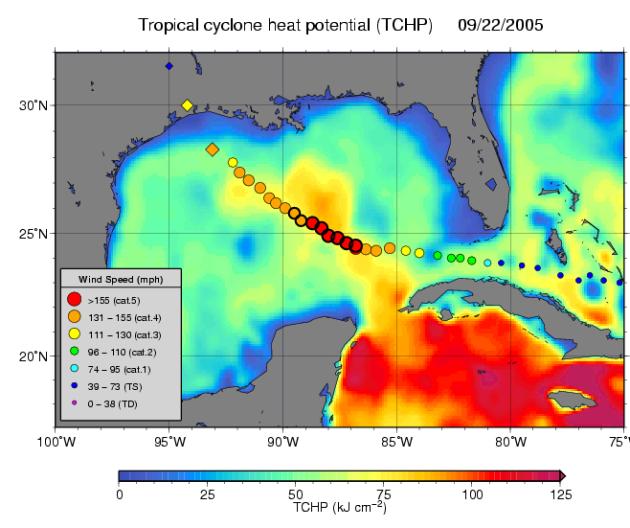
Tropical Cyclone Heat Potential (TCHP) field in the Gulf of Mexico during September 22, 2005. The path of Hurricane Rita is indicated with circles spaced every 3 hours with their size and color representing intensity (see legend). This hurricane intensified to category 5 as it traveled over the Loop Current and a warm core ring (the finger of red and yellow). Rita diminished to category 3 as its path went over a region of lower TCHP (and cooler waters) outside the Loop Current and ring. The diamonds indicate the National Hurricane Center predicted track and intensity as it makes landfall, and are spaced by 24 hours. Altimeter data on NASA's Jason-1, the US Navy's GFO, and the European Envisat satellites provide sea surface height data used in generating the TCHP fields.
The Jason satellite carries a dual-frequency radar altimeter. This instrument beams microwave pulses-at 13.6 and 5.3 Gigahertz, respectively-downward toward the Earth. To determine the ocean's height, the instrument precisely measures the time it takes for the microwave pulses to bounce off the surface and return to the spacecraft. This measure, multiplied by the speed of light, gives the range from the satellite to the ocean surface.
The joint U.S.-French Topex/Poseidon mission is managed by the JPL for NASA's Earth Science Enterprise, NASA Headquarters, Washington, D.C. JPL is a division of the California Institute of Technology in Pasadena. Research on Earth's oceans using Jason and other space-based capabilities is conducted by NASA's Earth Science Enterprise to better understand and protect our home planet. For more information on Topex/Poseidon, see http://topex-www.jpl.nasa.gov.)