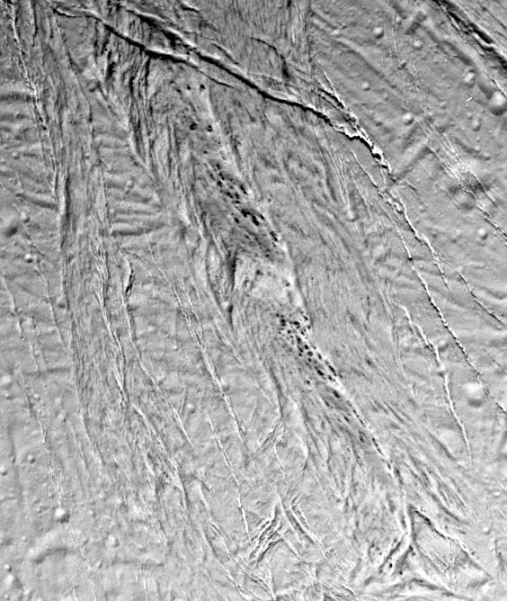
This high-resolution image from Cassini shows a region of "smooth plains" terrain on the surface of Saturn's moon Enceladus, located slightly north of the equator on the moon's Saturn-facing hemisphere. The area is 70 kilometer by 84 kilometer (43 mile by 52 miles).
The image shows a variety of tectonic features that attest to Enceladus' dynamic geological history. At the top of the image is a relatively fresh-looking crevasse system with individual fractures more than a kilometer wide. The crevasse system cross-cuts a complex northeast-to-southwest-trending system of older faults. A 12-kilometer-wide (7-mile-wide) band of crudely aligned, chevron-shaped features runs down the center of the image.
Among the most intriguing features in this view are a series of dark, small spots, 125 to 750 meters (400 to 2,500 feet) in diameter. The dark spots often seem to be aligned in chains parallel to narrow fractures. The contrast of the dark features with the surrounding bright terrain suggests that they may be compositionally distinct, but their origin is a new mystery.
The orientation of the image is such that north is approximately 30 degrees clockwise from the bottom of the frame. Enceladus is 505 kilometers (314 miles) in diameter.
The image was taken in visible light with the Cassini spacecraft narrow angle camera on Feb. 17, 2005, at a distance of 21,208 kilometers (13,178 miles) from Enceladus and at a Sun-Enceladus-spacecraft, or phase, angle of 27 degrees. Pixel scale in the image is 125 meters (410 feet) per pixel. The image has been contrast-enhanced to aid visibility.
The Cassini-Huygens mission is a cooperative project of NASA, the European Space Agency and the Italian Space Agency. The Jet Propulsion Laboratory, a division of the California Institute of Technology in Pasadena, manages the mission for NASA's Science Mission Directorate, Washington, D.C. The Cassini orbiter and its two onboard cameras were designed, developed and assembled at JPL. The imaging team is based at the Space Science Institute, Boulder, Colo.
For more information about the Cassini-Huygens mission, visit http://saturn.jpl.nasa.gov and the Cassini imaging team home page, http://ciclops.org.
