- Original Caption Released with Image:
-
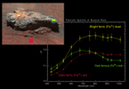
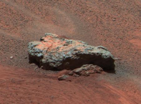
Figure 1This Mars Exploration Rover Opportunity panoramic camera image shows "Bounce Rock," a rock the airbag-packaged rover struck while rolling to a stop on January 24, 2004. This is the largest rock for as far as the eye can see, approximately 35 centimeters (14 inches) long and 10 centimeters (4 inches) high. There appears to be a dusty coating on the top of parts of the rock, which may have been broken when it was struck by the airbags. The rock was about 5 meters (16 feet) from the rover when this image was obtained. This is an enhanced color composite image from sol 36 of the rover's journey, generated using the camera's L2 (750 nanometer), L5 (530 nanometer), and L6 (480 nanometer) filters.Bounce Rock Spectra
Figure 1 above is a plot of panoramic camera spectra extracted from three different regions on the rock dubbed "Bounce." The yellow spectrum is from the yellow box in the image on the left, from the dusty top part of the rock. The spectrum is dominated by the signature of oxidized "ferric" iron (Fe3+) like that seen in the classic Martian dust. The red spectrum is from the darker Meridiani Planum soils that were disturbed by the airbag when it bounced near the rock. That spectrum is also dominated by ferric iron, though the reflectivity is lower. Scientists speculate that this may be because the grains are coarser in these soils compared to the dust. The green spectrum, which is from the right side of the rock, shows a strong drop in the infrared reflectance that is unlike any other rock yet seen at Meridiani Planum or Gusev Crater. This spectral signature is typical of un-oxidized "ferrous" iron (Fe2+) in the rock, perhaps related to the presence of volcanic minerals like olivine or pyroxene. The possibility that this may be a basaltic rock that is distinctly different from the rocks seen in the Eagle Crater outcrop is being intensively explored using the rover's other instruments.
- Image Credit:
-
NASA/JPL/Cornell
Image Addition Date: -
2004-04-02
|
 Planetary Data System


