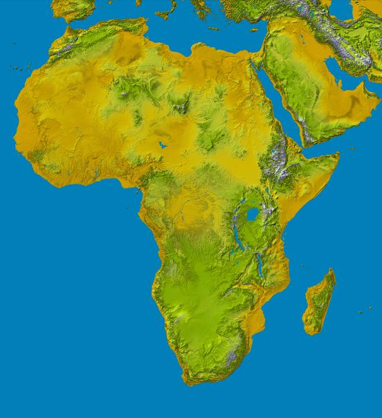
This color shaded relief image shows the extent of digital elevation data for Africa recently released by the Shuttle Radar Topography Mission (SRTM). This release includes data for all of the continent, plus the island of Madagascar and the Arabian Peninsula. SRTM flew on board the Space Shuttle Endeavour in February 2000 and used an interferometric radar system to map the topography of Earth's landmass between latitudes 56 degrees south and 60 degrees north.
The data were processed into geographic "tiles," each of which represents one by one degree of latitude and longitude. A degree of latitude measures 111 kilometers (69 miles) north-south, and a degree of longitude measures 111 kilometers or less east-west, decreasing away from the equator. The data are being released to the public on a continent-by-continent basis. This Africa segment includes 3256 tiles, almost a quarter of the total data set. Previous releases covered North America, South America and Eurasia. Forthcoming releases will include Australia plus an "Islands" release for those islands not included in the continental releases. Together these data releases constitute the world's first high-resolution, near-global elevation model. The resolution of the data released to the public in 2004 had a three arc second pixel size (1/1,200 of a degree of latitude and longitude), which is about 90 meters (295 feet). In 2014, most of these data were released at one arcsecond (about 30 meters or 98 feet), which reveals the data set's full resolution.
Coverage in the current data release extends from 35 degrees north latitude at the southern edge of the Mediterranean to the very tip of South Africa, encompassing a great diversity of landforms. The northern part of the continent consists of a system of basins and plateaus, with several volcanic uplands whose uplift has been matched by subsidence in the large surrounding basins. Many of these basins have been infilled with sand and gravel, creating the vast Saharan lands. The Atlas Mountains in the northwest were created by convergence of the African and Eurasian tectonic plates.
The geography of the central latitudes of Africa is dominated by the Great Rift Valley, extending from Lake Nyasa to the Red Sea, and splitting into two arms to enclose an interior plateau and the nearly circular Lake Victoria, visible in the right center of the image. To the west lies the Congo Basin, a vast, shallow depression which rises to form an almost circular rim of highlands.
Most of the southern part of the continent rests on a concave plateau comprising the Kalahari basin and a mountainous fringe, skirted by a coastal plain which widens out in Mozambique in the southeast.
Many of these regions were previously very poorly mapped due to persistent cloud cover or the inaccessibility of the terrain. Digital elevation data, such as provided by SRTM, are particularly in high demand by scientists studying earthquakes, volcanism, and erosion patterns for use in mapping and modeling hazards to human habitation. But the shape of Earth's surface affects nearly every natural process and human endeavor that occurs there, so elevation data are used in a wide range of applications.
In this index map color-coding is directly related to topographic height, with brown and yellow at the lower elevations, rising through green, to white at the highest elevations. Blue areas on the map represent water within the mapped tiles, each of which includes shorelines or islands.
Elevation data used in this image were acquired by the Shuttle Radar Topography Mission (SRTM) aboard the Space Shuttle Endeavour, launched on February 11, 2000. SRTM used the same radar instrument that comprised the Spaceborne Imaging Radar-C/X-Band Synthetic Aperture Radar (SIR-C/X-SAR) that flew twice on the Space Shuttle Endeavour in 1994. SRTM was designed to collect three-dimensional measurements of the Earth's surface. To collect the 3-D data, engineers added a 60-meter-long (200-foot) mast, installed additional C-band and X-band antennas, and improved tracking and navigation devices. The mission is a cooperative project between the National Aeronautics and Space Administration (NASA), the National Geospatial-Intelligence Agency (NGA) of the U.S. Department of Defense (DoD), and the German and Italian space agencies. It is managed by NASA's Jet Propulsion Laboratory, Pasadena, Calif., for NASA's Earth Science Enterprise, Washington, DC.
Orientation: North toward the top, Mercator projection
Image Data: Colored SRTM elevation model
Date Acquired: February 2000