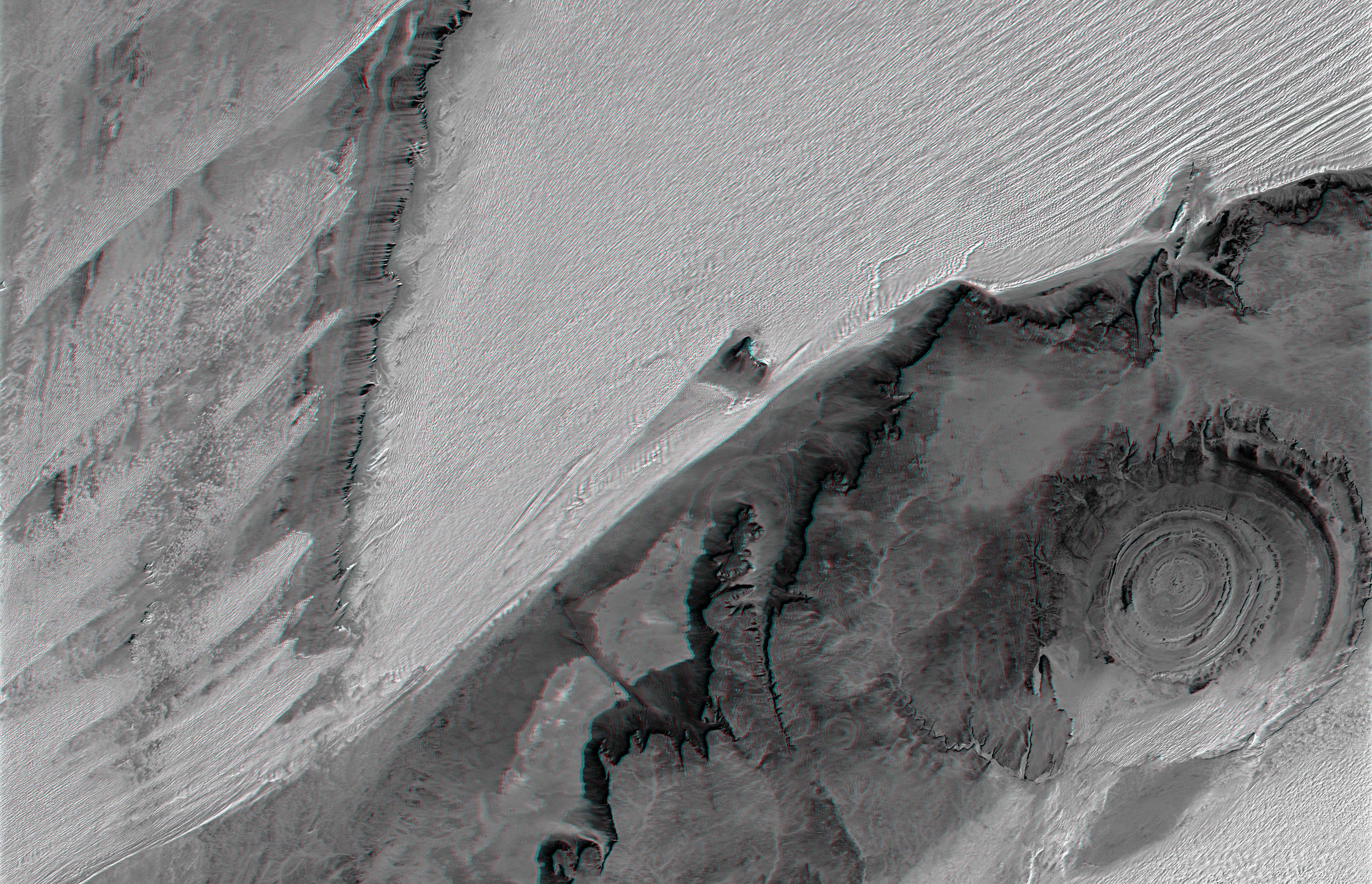
The prominent circular feature seen here, known as the Richat Structure, in the Sahara desert of Mauritania, is often noted by astronauts because it forms a conspicuous 50-kilometer-wide (30-mile-wide) bull's-eye on the otherwise rather featureless expanse of the desert. Initially mistaken for a possible impact crater, it is now known to be an eroded circular anticline (structural dome) of layered sedimentary rocks.
Extensive sand dunes occur in this region and the interaction of bedrock topography, wind, and moving sand is evident in this scene. Note especially how the dune field generally ends abruptly short of the cliffs as wind from the northeast (upper right) apparently funnels around the cliff, sweeping clean areas near the base of the cliff (particularly at the cliff point to the northwest, upper left, of the Richat Structure). Note also the isolated peak within the dune field. That peak captures some sand on its windward side, but mostly deflects the wind and sand around its sides, creating a sand-barren streak that continues far downwind.
To the west (left), a north-south trending bedrock ridge breaks up the sand field, and downwind from the ridge, streaks of dunes occur at certain locations. Upon close inspection, these streaks can be seen to be associated with saddles (low points) along the ridge, where sand preferentially passes over the ridge. This again shows how topographic features control the distribution of sand across the terrain.
This anaglyph was created by draping a Landsat reflectance infrared image over an SRTM elevation model, and then generating two differing perspectives, one for each eye. When viewed through special glasses, the anaglyph is a vertically exaggerated view of the Earth's surface in its full three dimensions. Anaglyph glasses cover the left eye with a red filter and cover the right eye with a blue filter For vertical scale, note that the prominent cliffs (image center) are about 300 meters (about 1000 feet) tall, the central rings of the Richat structure are about 80 meters (about 260 feet) tall, and the sand dunes rise about 80 meters (about 260 feet) above the adjacent terrain across the center of the image.
Elevation data used in this image was acquired by the Shuttle Radar Topography Mission (SRTM) aboard the Space Shuttle Endeavour, launched on February 11, 2000. SRTM used the same radar instrument that comprised the Spaceborne Imaging Radar-C/X-Band Synthetic Aperture Radar (SIR-C/X-SAR) that flew twice on the Space Shuttle Endeavour in 1994. SRTM was designed to collect three-dimensional measurements of the Earth's surface. To collect the 3-D data, engineers added a 60-meter-long (200-foot) mast, installed additional C-band and X-band antennas, and improved tracking and navigation devices. The mission is a cooperative project between the National Aeronautics and Space Administration (NASA), the National Geospatial-Intelligence Agency (NGA) of the U.S. Department of Defense (DoD), and the German and Italian space agencies. It is managed by NASA's Jet Propulsion Laboratory, Pasadena, Calif., for NASA's Earth Science Enterprise, Washington, D.C.
Size: 174.6 kilometers (108.3 miles) by 112.5 kilometers (69.8 miles)
Location: 21.4 degrees North latitude, 12.0 degrees West longitude
Orientation: North toward the top
Image Data: Landsat band 7
Date Acquired: February 2000 (SRTM), January 13, 1987 (Landsat)
