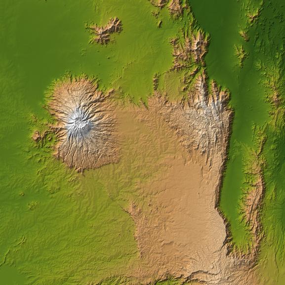
The striking contrast of geologic structures in Africa is shown in this shaded relief image of Mt. Elgon on the left and a section of the Great Rift Valley on the right.
Mt. Elgon is a solitary extinct volcano straddling the border between Uganda and Kenya, and at 4,321 meters (14,178 feet) tall is the eighth highest mountain in Africa. It is positioned on the Pre-Cambriam bedrock of the Trans Nzoia Plateau, and is similar to other such volcanoes in East Africa in that it is associated with the formation of the Rift Valley. However one thing that sets Mt. Elgon apart is its age.
Although there is no verifiable evidence of its earliest volcanic activity, Mt. Elgon is estimated to be at least 24 million years old, making it the oldest extinct volcano in East Africa. This presents a striking comparison to Mt. Kilimanjaro, the highest mountain in Africa at 5,895 meters (19,341 feet), which is just over one million years old. Judging by the diameter of its base, it is a common belief among geological experts that Mt. Elgon was once the highest mountains in Africa, however erosion has played a significant role in reducing the height to its present value.
Juxtaposed with this impressive mountain is a section of the Great Rift Valley, a geological fault system that extends for about 4,830 kilometers (2,995 miles) from Syria to central Mozambique. Erosion has concealed some sections, but in some sections like that shown here, there are sheer cliffs several thousand feet high. The present configuration of the valley, which dates from the mid-Pleistocene epoch, results from a rifting process associated with thermal currents in the Earth's mantle.
Two visualization methods were combined to produce the image: shading and color coding of topographic height. The shade image was derived by computing topographic slope in the northwest-southeast direction, so that northwest slopes appear bright and southeast slopes appear dark. Color coding is directly related to topographic height, with green at the lower elevations, rising through yellow and tan, to white at the highest elevations.
Elevation data used in this image were acquired by the Shuttle Radar Topography Mission aboard the Space Shuttle Endeavour, launched on Feb. 11, 2000. SRTM used the same radar instrument that comprised the Spaceborne Imaging Radar-C/X-Band Synthetic Aperture Radar (SIR-C/X-SAR) that flew twice on the Space Shuttle Endeavour in 1994. SRTM was designed to collect 3-D measurements of the Earth's surface. To collect the 3-D data, engineers added a 60-meter (approximately 200-foot) mast, installed additional C-band and X-band antennas, and improved tracking and navigation devices. The mission is a cooperative project between NASA, the National Geospatial-Intelligence Agency (NGA) of the U.S. Department of Defense and the German and Italian space agencies. It is managed by NASA's Jet Propulsion Laboratory, Pasadena, Calif., for NASA's Earth Science Enterprise, Washington, D.C.
Location: 1 degree north latitude, 35 degrees east longitude
Orientation: North toward the top, Mercator projection
Size: 223 by 223 kilometers (138 by 138 miles)
Image Data: shaded and colored SRTM elevation model
Date Acquired: February 2000