Released 14 November 2003
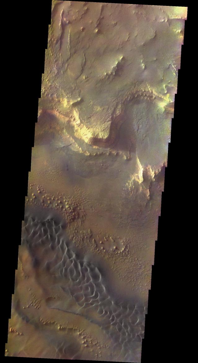
This spectacular view of the sunlit cliffs and basaltic sand dunes in southern Melas Chasma shows Mars in a way rarely seen: in full, realistic color. The colorization is the result of a collaboration between THEMIS team members at Cornell University and space artist Don Davis, who is an expert on true-color renderings of planetary and astronomical objects. Davis began with calibrated and co-registered THEMIS VIS multi-band radiance files produced by the Cornell group. Using as a guide true-color imaging from the Hubble Space Telescope and his own personal experience at Mt. Wilson and other observatories, he performed a manual color balance to match more closely the colors of previous visual Mars observations. He also did some manual smoothing and other image processing to minimize the effects of residual scattered light in the images. The result is a view of Mars that invites comparisons to Earth; a scene that one might observe out the window on a flight over the southwest United States, but not quite. The basaltic dunes are commonplace on Mars but a rare feature on Earth. The rounded knobs and elongated mesas on the canyon floor show an erosional style as exotic as Utah's Bryce Canyon but wholly familiar on Mars. Although the inhospitable Martian atmosphere cannot be seen, the magnificent Martian landscape on display in this image beckons space-suited human explorers and the sightseers who will follow.
Initial image processing and calibration by THEMIS team members J. Bell, T. McConnochie, and D. Savransky at Cornell University; additional processing and final color balance by space artist Don Davis.
Image information: VIS instrument. Latitude -12.7, Longitude 288.6 East (71.4 West). 19 meter/pixel resolution.
Note: this THEMIS visual image has not been radiometrically nor geometrically calibrated for this preliminary release. An empirical correction has been performed to remove instrumental effects. A linear shift has been applied in the cross-track and down-track direction to approximate spacecraft and planetary motion. Fully calibrated and geometrically projected images will be released through the Planetary Data System in accordance with Project policies at a later time.
NASA's Jet Propulsion Laboratory manages the 2001 Mars Odyssey mission for NASA's Office of Space Science, Washington, D.C. The Thermal Emission Imaging System (THEMIS) was developed by Arizona State University, Tempe, in collaboration with Raytheon Santa Barbara Remote Sensing. The THEMIS investigation is led by Dr. Philip Christensen at Arizona State University. Lockheed Martin Astronautics, Denver, is the prime contractor for the Odyssey project, and developed and built the orbiter. Mission operations are conducted jointly from Lockheed Martin and from JPL, a division of the California Institute of Technology in Pasadena.
