November 13, 2003
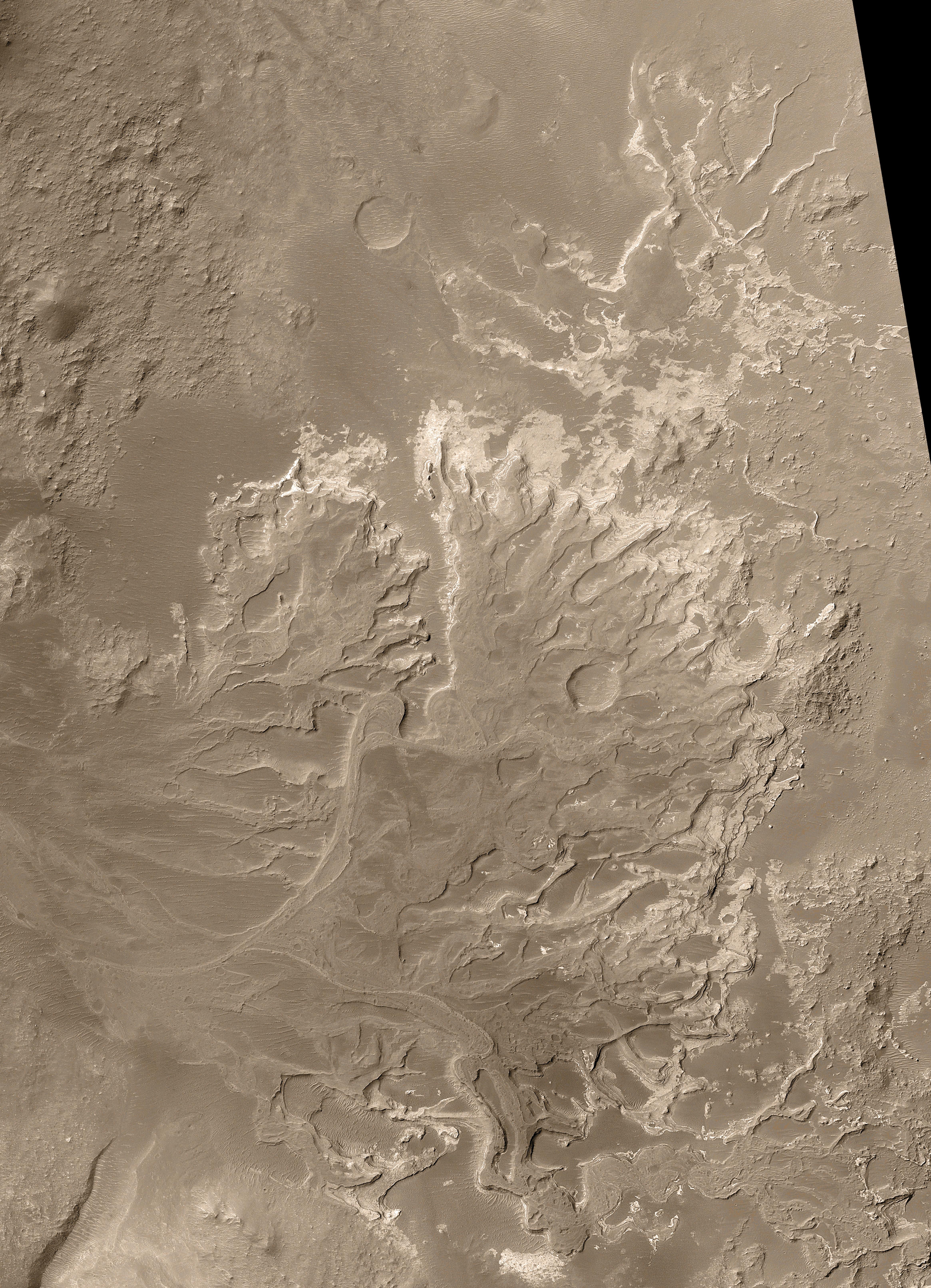
Details in a fan-shaped deposit discovered by NASA's Mars Global Surveyor orbiter provide evidence that some ancient rivers on Mars flowed for a long time, not just in brief, intense floods.
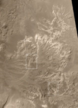
The apron of debris filling the middle of this picture from the spacecraft's Mars Orbiter Camera is a hardened and eroded distributory fan, a type of geological feature that includes river deltas and alluvial fans. Sediments transported through valleys by water on early Mars formed the 13-kilometer-long (8-mile) deposit in the distant past, when it was still possible for liquid water to flow across the martian surface.
Mars Orbiter Camera team members published discovery of this feature in the online edition of the journal Science. What is important about it? First, it provides unequivocal evidence that some valleys on Mars experienced persistent flow over considerable periods of time, as rivers do on Earth. Second, because the fan is today a deposit of sedimentary rock, it demonstrates that some sedimentary rocks on Mars were deposited in a liquid environment. Third, the fan's general shape, the pattern of its channels, and its low slopes provide circumstantial evidence that the feature was an actual delta -- that is, a deposit made when a river or stream enters a body of water. If so, this landform is a strong indicator that some craters and basins on Mars once held lakes. Hundreds of other locations on Mars where valleys enter craters and basins have been imaged by the Mars Orbiter Camera, but none has shown landforms like those presented here.
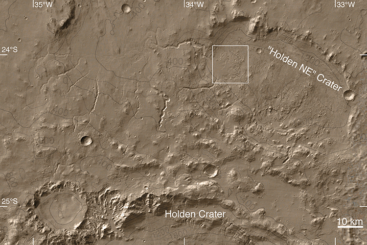
The picture is a mosaic of images acquired between August 2000 and September 2003. The area covered 14 kilometer (8.7 miles) by 19.3 kilometers (12 miles). North is up. Sunlight illuminates the scene from the left. The spacecraft's narrow-angle camera takes grayscale images; the color added is based on information from a camera on Mars Odyssey. The fan is in an unnamed crater that is 64 kilometers (40 miles) in diameter, at 24.3 degrees south latitude, 33.5 degrees west longitude. The crater lies northeast of a larger one named Holden Crater.
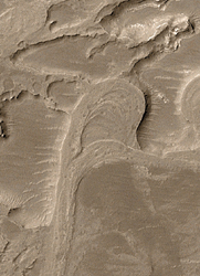
The fan is a fossil landform. That is, it is an eroded remnant of a somewhat larger and thicker deposit. The originally loose sediment was turned to rock and then eroded over time to present the features seen today. The channels through which sediment was transported are no longer present. Instead, only their floors remain, and these have been elevated by erosion so that former channels now stand as ridges. The floors of former channels became inverted in this way because they were more resistant to the forces of erosion, indicating they either were more strongly cemented than surrounding materials, or they have more coarse grains (which are harder to remove), or both.
Closer looks at two portions of the fan show observations critical to the story. White boxes overlaid on the image show the locations of those two areas.
 Click on image for larger view
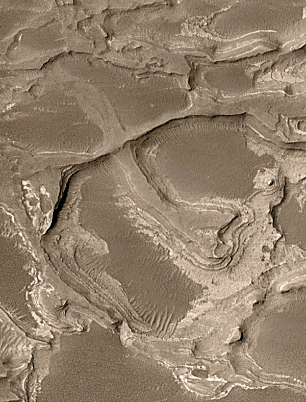
A region near the center of the fan has a loop, the inverted floor of a former meandering stream that was cut off as the channel adjusted its course. Meanders and cut-off meanders are the prime evidence for persistent flow of water through this area sometime early in martian history.
 Click on image for larger view
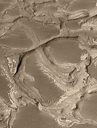
A region near the southeast edge of the fan shows inverted channels at different levels within the sedimentary deposit, indicating a long and complex history of water-related processes. One ridge crosses over another just left of the center of this frame. The top of the lower ridge is the former floor of a channel that was transporting water and sediment toward the lower right. The top of the upper ridge was once the floor of a channel that moved material toward the right or upper right. The lower ridge is the older channel. It was completely filled and buried beneath the surface when the upper channel formed.
 Click on image for larger view
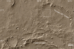
A regional context image shows the location of the fan with a white box. West of the fan are several valleys that fed water and sediment to the crater holding the fan (labeled "Holden NE" Crater). This map is a mosaic of daytime infrared images from the Thermal Emission Imaging System on Mars Odyssey. The contours are topography relative to Mars' zero-elevation level, derived from observations by the Mars Orbiter Laser Altimeter on Mars Global Surveyor. Sunlight illuminates the scene from the upper left. The 10-kilometer scale bar is about 6.2 miles across.
 Click on image for larger view
Additional information about Mars Global Surveyor is online at http://mars.jpl.nasa.gov/mgs/. The Jet Propulsion Laboratory, Pasadena, Calif., manages the Mars Global Surveyor mission for NASA's Office of Space Science, Washington, D.C. JPL is a division of the California Institute of Technology in Pasadena. JPL's industrial partner is Lockheed Martin Space Systems, Denver, which built and operates the spacecraft.
 Planetary Data System


