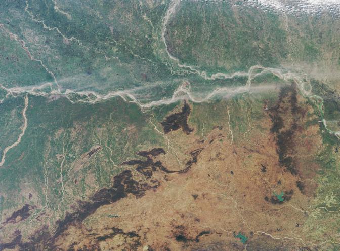
Here's another chance to play geographical detective! This natural-color image from NASA's Multi-angle Imaging SpectroRadiometer (MISR) covers an area of about 374 kilometers x 276 kilometers and was acquired in mid-February, 2005. This mystery concerns the geography and weather of the region. Use any reference material you like and answer the following 5 questions.
1. A major river enters at the left-hand image margin and runs across the image area. Two other large rivers also enter from the left-hand edge, one from the south, and one from the north. These three rivers converge near a regional capital city, apparent as the large area of pale gray pixels near the junction of these three rivers. Name that capital city and these three rivers.
2. The following four statements concern the art and prehistory from a particular jurisdictional region (in this case, a state) of which the aforementioned city is the capital. Three of the statements are true. Which statement is false?
(A) There is no archaeological evidence of Neolithic settlement within 160 kilometers of the capital city.
(B) Within the capital city there are many pre and proto-historic artworks preserved by the state-owned art museum.
(C) A distinctive folk art painting style from that state is traditionally passed down from mothers to their daughters.
(D) At least three stone-age archaeological sites are known to exist within that state.
3. Along the banks of the major river that traverses the image, some dust has been swept aloft by strong winds. During this season, is the east-west component of the surface winds typically from the west, or do such winds generally blow from the east?
4. Another major river enters at the upper image margin, and curves downward to converge with the major river that runs across the entire image. Three of the following four statements about the area surrounding the curved river are true. Which statement is false?
(A) The river has shifted its course by more than 100 kilometers in the past two and a half centuries.
(B) During the summer floods the river can attain a width of over 30 kilometers.
(C) For the most part, the series of embankments that were constructed in the 1950s to control the shifting nature of the river, work successfully to reduce the severity and duration of the annual flooding.
(D) An animal belonging to the order Cetacea can be found in this river.
5. The tan and orange hues in the lower portion of the image area are associated with a plateau region in which many minerals have been mined. Three of the following four statements about mining in the region are true. Which one is false?
(A) Much of the mineral wealth of the region was transferred to a new jurisdiction in November 2000, when part of the plateau region became a new state.
(B) Significant reserves of lateric nickel, molybdenum and tin have been discovered here.
(C) Iron ore played an influential role in the region's history since it is abundant here but is rather scarce in neighboring areas.
(D) Gold, uranium, and at least two copper ore extraction sites are found within the region.
Quiz Rules
Send us your answers, name (initials are acceptable if you prefer), and your hometown by the quiz deadline of Tuesday, July 5, 2005, using the Quiz answer form, http://www-misr2.jpl.nasa.gov/education/answer.cfm. Answers will be published on the MISR web site. The names and home towns of respondents who answer all questions correctly by the deadline will also be published in the order responses were received. The first 3 people on this list who are not affiliated with NASA, JPL, or MISR and who have not previously won a prize will be sent a print of the image.
A new "Where on Earth...?" mystery appears as the MISR "latest featured image" approximately once every two months. New featured images are released on Wednesdays at noon Pacific time on the MISR home page, http://www-misr.jpl.nasa.gov. The image also appears on the Earth Observatory, http://earthobservatory.nasa.gov/, and on the Atmospheric Sciences Data Center home pages, http://eosweb.larc.nasa.gov/, though usually with a several-hour delay.
MISR was built and is managed by NASA's Jet Propulsion Laboratory, Pasadena, CA, for NASA's Office of Earth Science, Washington, DC. The Terra satellite is managed by NASA's Goddard Space Flight Center, Greenbelt, MD. JPL is a division of the California Institute of Technology.