The answers to this quiz appear in blue below each question.
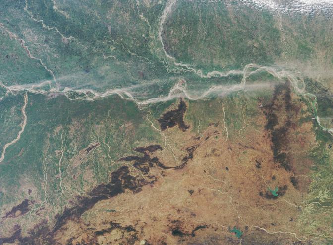
1. A major river enters at the left-hand image margin and runs across the
image area. Two other large rivers also enter from the left-hand edge, one
from the south, and one from the north. These three rivers converge near a
regional capital city, apparent as the large area of pale gray pixels near
the junction of these three rivers. Name that capital city and these three
rivers.
The image area encompasses the eastern Ganges plain and the States of
Bihar and Jharkhand. In the top part of this image, Bihar is bisected by the
Ganges River (which is also popularly known by its Hindu name, Ganga).
The Son River (also spelled Sone River) joins the Ganges from the south,
and the Gandak River joins from the north. A very small portion of the
Gaghra River is also apparent here, as it joins with the Ganges just upstream
from its confluence with the Sone. Patna, the capital city of Bihar, is located
downstream from the Sone and opposite the confluence of the Ganges and
the Gandak. The smaller river of Punpun only becomes navigable during
the rains.
2. The following four statements concern the art and prehistory from a
particular jurisdictional region (in this case, a state) of which the
aforementioned city is the capital. Three of the statements are true.
Which statement is false?
(A) There is no archaeological evidence of Neolithic settlement within
160 kilometers of the capital city.
(B) Within the capital city there are many pre and proto-historic artworks
preserved by the state-owned art museum.
(C) A distinctive folk art painting style from that state is traditionally
passed down from mothers to their daughters.
(D) At least three stone-age archaeological sites are known to exist
within that state.
A is false
Patna became a great city by about 300 BC (Patna was previously called
Pataliputra). In its long history, the surrounding region has seen the rise and
fall of several kingdoms and empires. There are more than twenty
archaeological sites within Bihar, and there are at least three stone-age
archaeological sites, including several Neolithic settlements such as the one
at Chirand (which is situated about 50 kilometers from Patna). The state-owned
Patna Museum boasts a large number of pre- and proto-historic objects of
relevance to Indian art and history. An important painting style from Bihar is
the art of the Madhubani, which is traditionally passed from mothers to their
daughters.
3. Along the banks of the major river that traverses the image, some dust
has been swept aloft by strong winds. During this season, is the east-west
component of the surface winds typically from the west, or do such winds
generally blow from the east?
Either "from the west" or "neither" (no east-west component) are correct
The large scale (synoptically driven) winds tend to be rather weak in the
eastern Ganges valley, and the direction of these winds near Bihar during
the winter (December - February) are governed by ones relative position to
the dominant high pressure system. However, for a long stretch along the
Ganges River there is a very weak wind component that is from the west.
Data for this region and season from the National Centers for Environmental
Prediction (NCEP) indicate a very weak prevailing wind component from the
west at 850 mb (850 mb is one of the lower levels of the atmosphere). Winter
winds data from NCEP were reanalyzed for Bihar in a peer-reviewed journal
paper that is available online at: http://www-misr.jpl.nasa.gov/mission/pubs/fulltext/DiGirolamo2004-GRL.pdf.
Please note however, that the NCEP data does not capture mesoscale driven
(smaller-scale) winds such as mountain-valley breezes. Close to the foothills of
the Himalayas, the wind direction is governed by the local topography, and
mountain-valley breezes will predominate.
4. Another major river enters at the upper image margin, and curves
downward to converge with the major river that runs across the entire
image. Three of the following four statements about the area surrounding
the curved river are true. Which statement is false?
(A) The river has shifted its course by more than 100 kilometers in the
past two and a half centuries.
(B) During the summer floods the river can attain a width of over 30
kilometers.
(C) For the most part, the series of embankments that were constructed in
the 1950s to control the shifting nature of the river, work successfully
to reduce the severity and duration of the annual flooding.
(D) An animal belonging to the order Cetacea can be found in this river.
C is false
The Kosi River in north Bihar is notorious for the meandering behavior of
its east-to-west course. In the past 250 years, the Kosi has moved
westwards by more than 100 kilometers. During the summer floods, the
Kosi has been known to attain a width of over 30 km on the
nearly flat Ganges plain. In 1955, the river was harnessed with the
construction of a barrage. Since then, a series of canals, levees and
embankments have channeled the river, providing plenty of irrigation
water for north-east Bihar. Although the embankments have calmed the
Kosi, flow regulation can not be said to have reduced the severity and
duration of flooding, and embankment breaches have occurred in many
years including 1968, 1984, 1987, 1988, 2001, 2002, 2003 and 2004.
The breaches are partly due to the extremely high silt content of the
Kosi waters, which cause erratic and unpredictable morphological changes
and bank erosion. As the embankments become choked with silt, seepage
occurs and forces the bed level and the water table to rise. The
embankments have been raised over 2 meters since their original
construction in order to keep pace with the rising river bed. Some amount
of previously arable countryside has been devastated by this rise in the
water table, and it is reported that during the wet monsoon season, the
only dry place for some villagers living at the southern tip of the West Kosi
embankment is atop the embankment itself. Although now extremely rare,
the Ganges River dolphin, Platanista gangetica, is still found within the Kosi River.
5. The tan and orange hues in the lower portion of the image area are
associated with a plateau region in which many minerals have been mined.
Three of the following four statements about mining in the region are
true. Which one is false?
(A) Much of the mineral wealth of the region was transferred to a new
jurisdiction in November 2000, when part of the plateau region became a
new state.
(B) Significant reserves of lateric nickel, molybdenum and tin have been
discovered here.
(C) Iron ore played an influential role in the region's history since it
is abundant here but is rather scarce in neighboring areas.
(D) Gold, uranium, and at least two copper ore extraction sites are found
within the region.
B is false (C also accepted as false)
Through bifurcation of Bihar in November 2000, the new Indian state
of Jharkhand was formed. Jharkhand is comprised of about 45% of
the geographical area of undivided Bihar. The southern portion of
Bihar became Jharkhand, which now includes most of the
Chhotanagpur plateau, to which many of the mineral resources
of the region are bestowed. Northeastern India does not possess
significant quantities of lateric nickel, molybdenum or tin. However,
Bihar (before division) produced much of India's copper, and both
gold (south of Chhotanagpur) and uranium (at Jadugudda in southern
Jharkhand) are found today in Jharkhand. The southern Chhotanagpur
plateau region was the single most important source for iron ore, coal,
and bauxite within India, and undivided Bihar produced about 45% of
India's iron ore. Iron was also extremely important for India's ancient
history, since the increasing adoption of iron implements made it
possible to remove dense forest and plough heavy clay soils, but
rich iron ore deposits were only found within southern Bihar and
Orissa. Ancient cities in Bihar (such as Rajgir) are testimony to these
developments. The iron ore deposits of southern Bihar and Orissa were
the only reliable sources of iron ore during India's ancient history. Since
the iron ore deposits at Orissa are situated a few hundred kilometers to
the south of this image, C is also accepted as a false statement.
MISR was built and is managed by NASA's Jet Propulsion Laboratory,
Pasadena, CA, for NASA's Office of Earth Science, Washington, DC. The
Terra satellite is managed by NASA's Goddard Space Flight Center,
Greenbelt, MD. JPL is a division of the California Institute of
Technology.