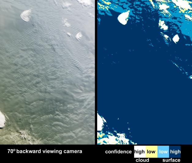
As it passed over Antarctica on December 16, 2004, the Multi-angle Imaging SpectroRadiometer (MISR) on NASA's Terra satellite captured this image showing a wavy pattern in a field of white. At most other latitudes, such wavy patterns would likely indicate stratus or stratocumulus clouds. MISR, however, saw something different. By using information from several of its multiple cameras (each of which views the Earth's surface from a different angle), MISR was able to tell that what looked like a wavy cloud pattern was actually a wavy pattern on the ice surface. One of MISR's cloud classification products, the Angular Signature Cloud Mask (ASCM), correctly identified the rippled area as being at the surface.
In this image pair, the view from MISR's most oblique backward-viewing camera is on the left, and the color-coded image on the right shows the results of the ASCM. The colors represent the level of certainty in the classification. Areas that were classed as cloudy with high confidence are white, and areas where the confidence was lower are yellow; dark blue shows confidently clear areas, while light blue indicates clear with lower confidence. The ASCM works particularly well at detecting clouds over snow and ice, but also works well over ocean and land. The rippled area on the surface which could have been mistaken for clouds are actually sastrugi -- long wavelike ridges of snow formed by the wind and found on the polar plains. Usually sastrugi are only several centimeters high and several meters apart, but large portions of East Antarctica are covered by mega-sastrugi ice fields, with dune-like features as high as four meters separated by two to five kilometers. The mega-sastrugi fields are a result of unusual snow accumulation and redistribution processes influenced by the prevailing winds and climate conditions. MISR imagery indicates that these mega sastrugi were stationary features between 2002 and 2004.
Being able to distinguish clouds from snow or ice-covered surfaces is important in order to adequately characterize the radiation balance of the polar regions. However, detecting clouds using spaceborne detectors over snow and ice surfaces is notoriously difficult, because the surface may often be as bright and as cold as the overlying clouds, and because polar atmospheric temperature inversions sometimes mean that clouds are warmer than the underlying snow or ice surface. The Angular Signature Cloud Mask (ASCM) was developed based on the Band-Differenced Angular Signature (BDAS) approach, introduced by Di Girolamo and Davies (1994) and updated for MISR application by Di Girolamo and Wilson (2003). BDAS uses both spectral and angular changes in reflectivity to distinguish clouds from the background, and the ASCM calculates the difference between the 446 and 866 nanometer reflectances at MISR's two most oblique cameras that view forward-scattered light. New land thresholds for the ASCM are planned for delivery later this year.
The Multi-angle Imaging SpectroRadiometer observes the daylit Earth continuously and every 9 days views the entire globe between 82° north and 82° south latitude. This image area covers about 277 kilometers by 421 kilometers in the interior of the East Antarctic ice sheet. These data products were generated from a portion of the imagery acquired during Terra orbit 26584 and utilize data from within blocks 159 to 161 within World Reference System-2 path 63.
MISR was built and is managed by NASA's Jet Propulsion Laboratory, Pasadena, CA, for NASA's Office of Earth Science, Washington, DC. The Terra satellite is managed by NASA's Goddard Space Flight Center, Greenbelt, MD. JPL is a division of the California Institute of Technology.