The answers to this quiz appear in blue below each question.
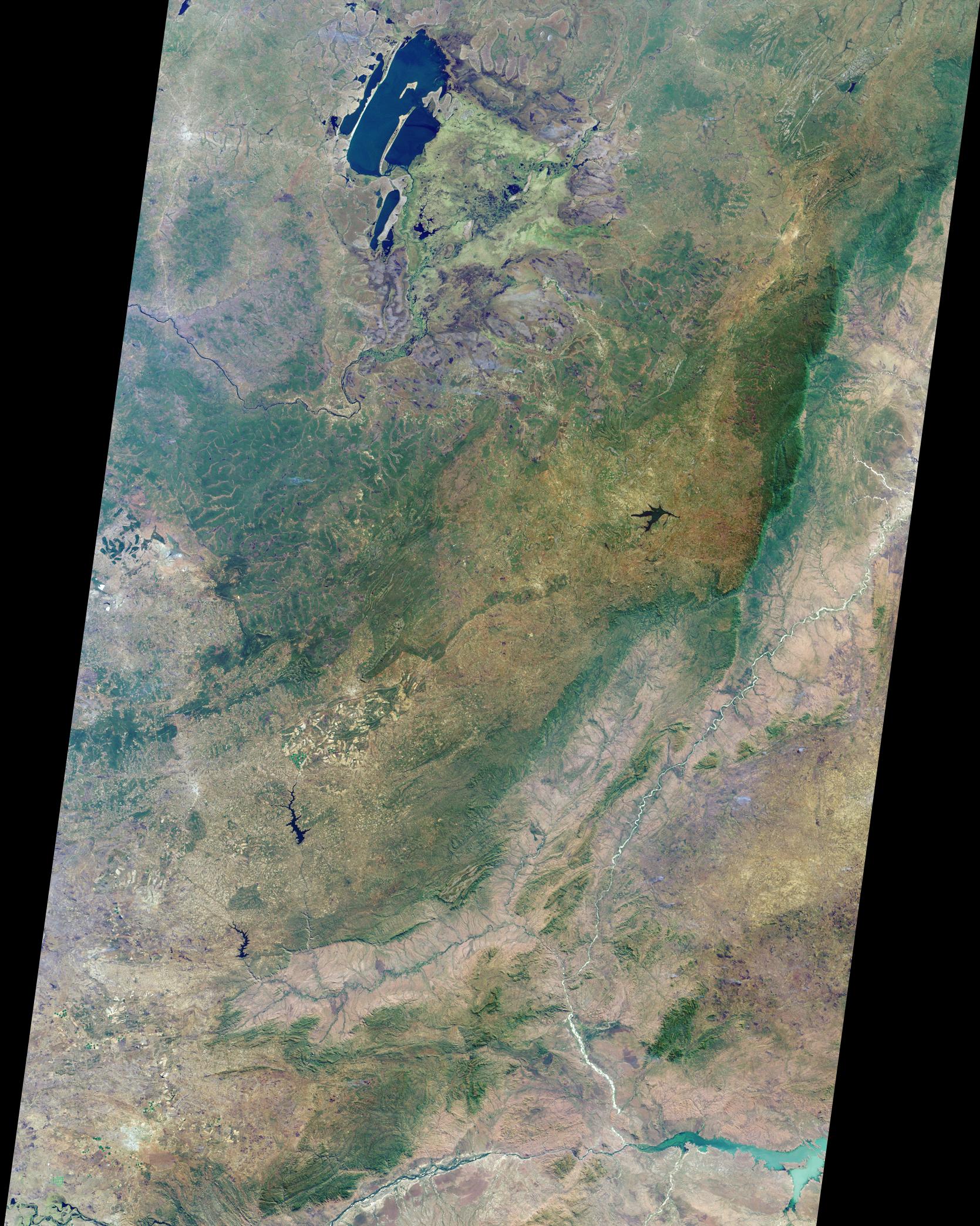
1. Name the nation(s) that appear and any national capital cities included
within the image area.
Answer: The nations that appear within the image area are Zambia, the
Democratic Republic of the Congo, Mozambique, and the extreme north
part of Zimbabwe. Zambia’s capital city of Lusaka appears as the pale
gray-colored area in the lower left-hand corner of the image.
2. At the top of the image are several large lakes with extensive swamps
and marshlands to the east and southeast. Three of the following four
statements about the marshlands are true. Which one is false?
(A) A large, solitary bird, whose name derives from its unusually-shaped
bill and who is the only known species of its genus, is regularly sighted
here in July.
(B) The end of the wet season occurred less than a month prior to the
acquisition of this image, and water levels in the marshes are still high.
(C) At least two different kinds of semi-aquatic ruminants can be found in
the swamps and marshlands of this region.
(D) Industrial fishing is not allowed in any of the lakes or swamps.
Answer: B is false.
The Bangweulu swamps are part of a large complex of
major lakes, and the Chambeshi and Luapula as major rivers. One of the most
rare and elusive birds in Africa, the shoebill stork (Balaeniceps rex) favors the
Bangweulu swamps as one of their last remaining habitats. The rainy season in
Zambia is from November to April, so when this image was captured (July)
several months had elapsed since the onset of the dry season. Unique to the
floodplains of the Bangweulu swamps is the water-loving black lechwe (a
semi-aquatic antelope). There are also sitatunga (another antelope adapted to
wetland areas) and hippos. Bangweulu is an open access fishery, but with a
number of fishing restrictions, and a prohibition against industrial fishing.
3. In the center left-hand portion of the image is a large green-colored
area, bordered by a big river on its northern flank. Three of the following
four statements about this area are true. Which one is false?
(A) Despite intensive copper mining activities to the south, this forested
region does not sit atop a rich deposit of copper ore.
(B) The pattern of bright green and tan situated below the green area
indicates a region of many large-scale commercial farms.
(C) One nation's government is planning to construct a high grade road
northwards across the area, although it is part of a different nation's
territory.
(D) During the 1960s, political leaders of the area made an unsuccessful
attempt to secede as an independent nation.
Answer: A is false.
The mineral-rich province of the Democratic Republic
of Congo which thrusts into the center of Zambia, is known variously as
Shaba, Katanga, and also is also sometimes called the Congo Pedicle. The
pattern of bright green and tan below the green area is the Mkushi farming
block, a commercial maize growing area. A cluster of circular green areas
are visible in this area, indicating center pivot irrigation. The Luapula river
runs from Lake Bengweulu along the border between Zambia and the DRC,
and the government of Zambia has begun planning work on the tarring of the
so-called "pedicle road" across Katanga and the construction of a bridge
across the Luapula river. Zambia's heavily-developed Copperbelt and the
Congo Pedicle are both within central African Copper Belt, and the pedicle
area has often been the subject of dispute. In 1961, copper-rich Katanga under
Moise Tshombe attempted to secede from the rest of the Congo.
4. A steep escarpment traverses the right-hand portion of the image, and a
fertile valley is found to its east. Three of the following four statements
about this region are true. Which one is false?
(A) This escarpment is part of a 6000 kilometer-long fault system.
(B) The strange-looking tree, Adansonia digitata, is commonly found in some
parts of this region.
(C) The soils in the valley are relatively nutrient-rich because of their
volcanic origin.
(D) Both Ceratotherium simum and Loxodonta spp. can be found within these
areas.
Answer: Both C and D accepted as false.
The steep escarpment in this
image lies at the southern end of the Great Rift Valley, a vast rift fault system
that extends from Lebanon to Mozambique. The Great Rift Valley is created by
the rifting and separation of the African and Arabian tectonic plates and is
actually a continental extension of the midoceanic ridge. To the east of the
central plateau region is the Muchinga Escarpment, which falls about a
thousand meters to the Luangwa Valley. The Luangwa Valley is one of the
major agro-economical zones in Zambia, and in the parkland and game viewing
areas of the Luangwa, vegetation and wildlife is lush and diverse. Pockets of
baobab trees (Adansonia digitata) are still common here, despite the large
numbers of elephants which eat the boabab and can impede the ability of
mature boabab trees to reproduce. The Luangwa’s soils are a mixture of alluvial
and medium to heavy textured soils. Although the soils are considered to be
relatively nutrient-rich compared with other soil types in Zambia, these soils are
not considered to be derived from volcanic sources because the basement rocks
are mostly sedimentary, and only the intrusions are volcanic. The endangered
White Rhino (Ceratotherium simum) are not found in this part of Africa.
5. In the very bottom right of the image, at the junction of two rivers, is
a large, pale green lake. Three of the following four statements about it
are true. Which one is false?
(A) Give or take a few meters, the average depth of the lake is about 25
meters.
(B) Almost five thousand people living downstream from the lake lost their
homes during the severe floods of 2001.
(C) The "lake" was created by dam construction and is, in fact, a reservoir
boasting the largest holding capacity of any on the continent.
(D) A side effect of the dam is that the floodplain downstream no longer
receives yearly inundation by floodwaters.
Answer: Either B or C accepted as false
The Cahora Bassa Lake is actually an artificial reservoir on the Zambezi River,
resulting from the construction of the Cahora Bassa dam in 1974. The Cahora
Bassa dam, and the Kariba dam further upstream, were constructed for the
production of hydroelectricity. Although the deepest parts of the Lake extend to
about 157 meters, the average depth is between 21 and 26 meters. The 2001
flooding event in Mozambique affected about 400,000 people and displaced
approximately 77,000 from their homes. The Lake Kariba reservoir upstream on
the Zambezi has a larger holding capacity than Cahora Bassa. Annual flooding
used to renew the soil of nearby farmland, but the Cahora Bassa and Kariba
dams now prevent yearly flooding.
MISR was built and is managed by NASA's Jet Propulsion Laboratory,
Pasadena, CA, for NASA's Office of Earth Science, Washington, DC. The
Terra satellite is managed by NASA's Goddard Space Flight Center,
Greenbelt, MD. JPL is a division of the California Institute of
Technology.
