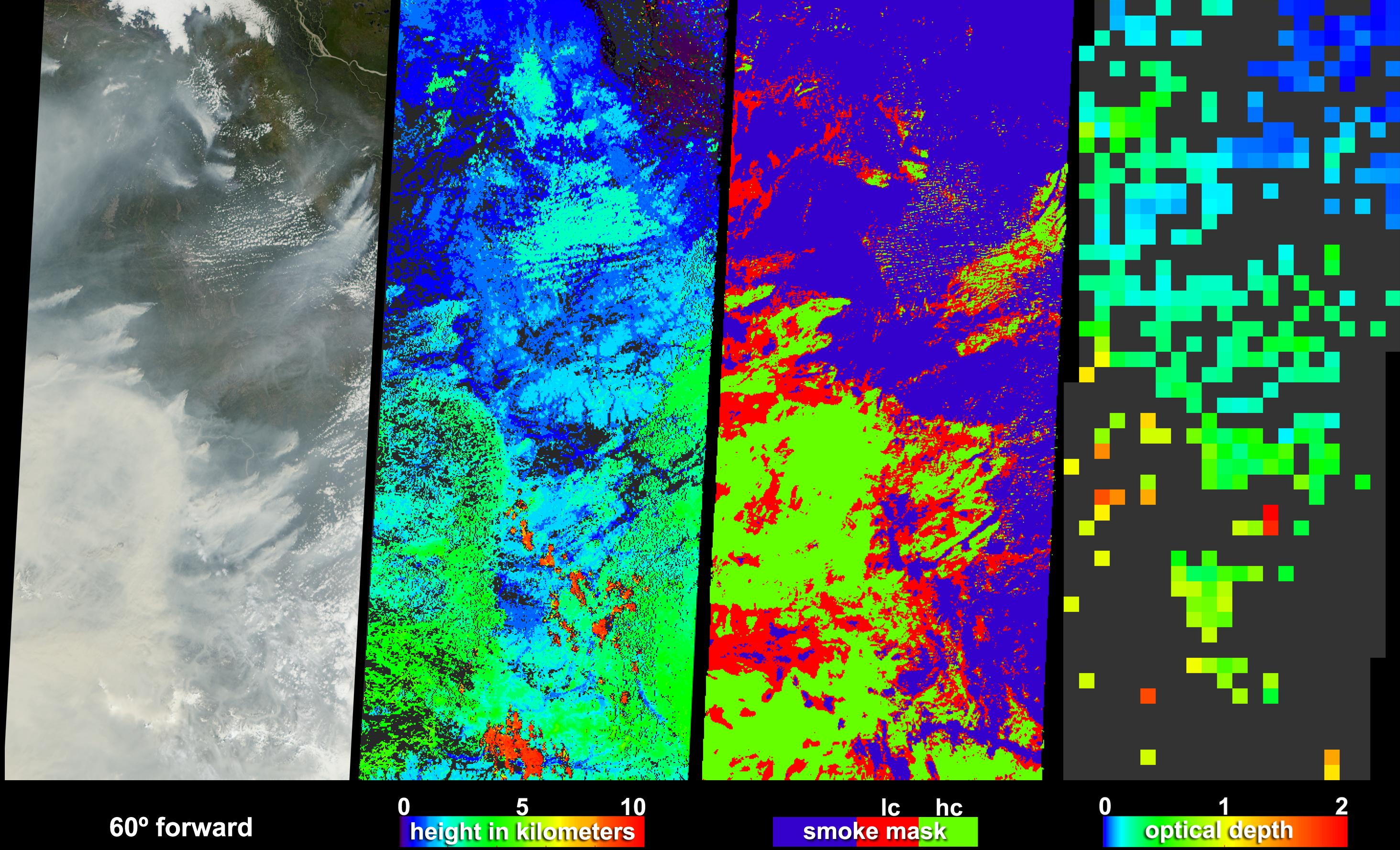
Large lightning-induced fires were active in Alaska and the Yukon Territory from mid-June to mid-July, 2004. Thick smoke particles filled the air during these fires, prompting Alaskan officials to issue air quality warnings. Some of the smoke from these fires was detected as far away as New Hampshire. These visualizations were captured on June 30th by the Multi-angle Imaging SpectroRadiometer (MISR) on NASA's Terra spacecraft. Here, MISR distinguishes clouds from smoke and retrieves heights and optical depths for the smoke -- information which will help to improve models of how smoke aerosols are transported.
The images cover an area extending from the Mackenzie Bay in northwest Canada, through the Alaskan Interior and along the Alaska-Yukon border, south to the Wrangell Mountains. The first panel in the series is a natural-color image from MISR's 60° forward viewing camera. Smoke plumes notable along the right-hand edge are situated southwest of the Peel River in the Yukon Territory, and plumes extending west from the left-hand edge are situated in the vicinity of the Yukon River and the town of Eagle at the Alaska-Canada border. In the lower portion of the image, thick smoke obscures the Wrangell Mountain range.
The next panel in the series is a stereoscopic height field, in which topography, smoke plumes and clouds are all being detected. Analysis indicates that most of the smoke and many low clouds are situated at heights between about 1 and 4 kilometers above the surface, while a few high clouds attained much greater altitudes.
The third panel from the left is a smoke mask, in which the image is classified as either non-smoke, or as smoke with low confidence (lc) or high confidence (hc), represented by the blue, red and green pixels, respectively. Many of the actual smoke "plumes" were identified as high-confidence smoke, including parts of plumes in the Peel River region (upper right) and Yukon River/Alaska-Canada border region (left-hand edge). This smoke mask is produced by a computerized "machine-learning" classifier which detects smoke by examining the spectral, textural, and angular features in the radiances from three oblique-viewing MISR cameras. Ultimately, the classifier will be trained to identify plume-like shapes, thus making it possible to automatically isolate plume heights from the stereo product.
The right-hand panel displays MISR's aerosol optical depth retrieval, in which the brightness and contrast changes of the surface at different view angles are used to measure the attenuation of sunlight as it passes through a column of the atmosphere. Increasing amounts of smoke aerosol appear as green, yellow, orange and red pixels, and clearer skies are indicated by blue pixels. Areas where the aerosol optical depth could not be retrieved, either because the smoke was too thick to see the surface contrast or because the presence of clouds precluded a retrieval, are shown in dark gray.
The Multi-angle Imaging SpectroRadiometer observes the daylit Earth continuously and every 9 days views the entire globe between 82 degrees north and 82 degrees south latitude. The non-animated data products were generated from a portion of the imagery acquired during Terra orbits 24123. The still panels cover an area of about 400 kilometers 898 kilometers, and use data from blocks 35 to 41 within World Reference System-2 path 64.
MISR was built and is managed by NASA's Jet Propulsion Laboratory, Pasadena, Calif., for NASA's Office of Earth Science, Washington, DC. The Terra satellite is managed by NASA's Goddard Space Flight Center, Greenbelt, Md. JPL is a division of the California Institute of Technology.
