The answers to this quiz appear in blue below each question.
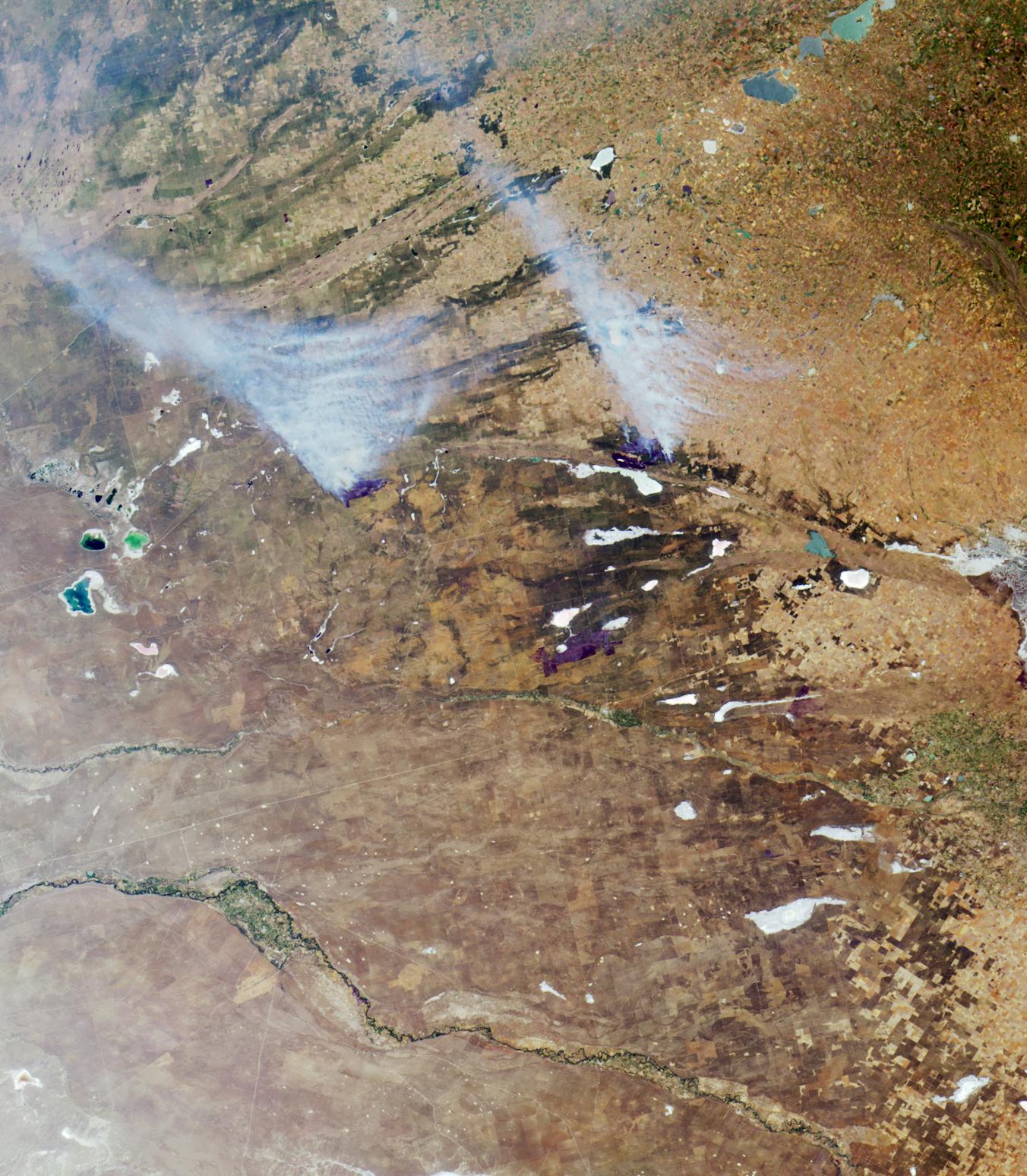
1. Of the two large smoke plumes rising from fires near image center, one
is burning within 10 kilometers of a major gas pipeline.
False. The major gas pipeline (the Nueba II) connecting the gas field in Neuquen to the port city of Bahia Blanca runs almost parallel and quite close to the highway (apparent as a thin white line crossing the Rio Colorado from southwest to northeast) that connects the two cities. At its closest point, this pipeline is at least 50 kilometers away from either of the two smoke plumes.
2. The blue, green, and silver-colored lakes and lagoons, and the white
salt-encrusted lakes and marshes that appear throughout the image area, are
usually drier during winter and wetter in the summer.
Both True and False accepted. La Pampa and Buenos Aires provinces receive most rainfall during summer, when the long dry season is broken. However, some years are driest during the middle of summer. In the summer of 2000/2001, the rains were late and the region was dry until after mid-summer.
3. Agriculture in this region is devoted primarily to vegetable and fruit
production.
False. The main agricultural products are livestock, forage and cereal crops, soybeans and oil seeds. Fruit and vegetable production does not predominate.
4. There are fewer trees and forests in the region today than there were
500 years ago.
False. The native grasslands of the Pampas are reknowned for the scarcity of trees. Although there has been forest loss in surrounding regions, and although much of the native vegetation of the Pampas has been replaced by modern agriculture and cattle ranching, there were no forests in the Pampas 500 years ago.
5. The fresh waters that feed the silver-colored lakes in the upper-right
corner of the image are described as an aid to digestion in a 19th century
novel by a French science fiction author.
True. The waters of a small brook that feeds this chain of lakes (the Rio Guamini) is praised in Jules Verne’s book "In Search of the Castaways."
6. The silver-colored area along the right-hand edge at image center is
situated along the boundary of a city that was originally named for its
white beaches.
True. The silver area corresponds with the outskirts of Bahia Blanca. The city was called “White Bay” because of its white, salt-encrusted shores that surround the bay. The bay and the city itself are not shown.
7. In the same year in which this image was acquired, a water contamination
event occurred and residents of the aforementioned city were warned not to
drink from the municipal water supply.
True. In April 2000 the city of Bahia Blanca warned its 420,000 residents to avoid using tap water because of the presence of toxic bacteria in the water at that time.
8. The dark blue lake apparent at left-hand edge of image center is named
for its sweet waters and supports year-round commercial and sport fishing.
False. The dark blue lake, "La Dulce," is named for its fresh water, and there is sport and commercial fishing for "pejerrey," but there are long closed seasons, or "vedas," and commercial fishing is allowed only a few months of the year.
9. The waters of the river that ends in a large alluvial fan (situated near
the right-hand edge below image center), are saltier than the waters of the
river below it, which continues to flow beyond the right-hand image edge.
True. The river that ends in the large alluvial fan is the Rio Colorado, and the river below it is the Rio Negro. At times, the excessively salty waters of the Salado-Chadileuvu-Curaco river system contaminate the waters of the Rio Colorado.
MISR was built and is managed by NASA's Jet Propulsion Laboratory,
Pasadena, CA, for NASA's Office of Earth Science, Washington, DC. The
Terra satellite is managed by NASA's Goddard Space Flight Center,
Greenbelt, MD. JPL is a division of the California Institute of
Technology.
