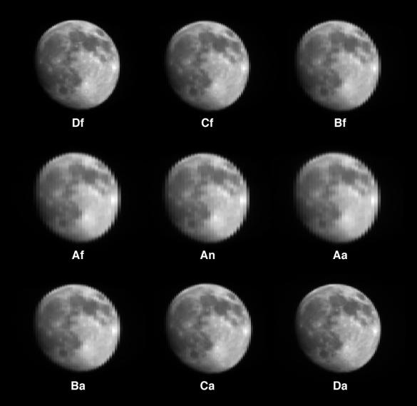
On April 14, 2003, a special maneuver of the Terra spacecraft was performed as it traversed the nightside of orbit 17672. This maneuver entailed a "backward somersault" of the spacecraft as it pitched end-over-end, allowing the normally Earth-viewing instruments to look at deep space and the waxing gibbous Moon. The purpose of this acrobatic feat is to assist in the calibration of several of Terra's instruments. Over a 16-minute interval, the lunar disk passed through the fields-of-view of all nine MISR cameras, resulting in this unique set of images. Shown here are "raw" red-band data, with no adjustments for radiometric calibration. Because the pitch rate of the spacecraft resulted in different pixel spacings in the left-right and up-down directions, the aspect ratios of the raw images have been adjusted to provide roughly circular disks.
Each image is labeled with the name of the camera which acquired it. The "D" cameras are the ones which normally view the Earth at the most oblique angles, and the letters "f" and "a" denote fore- and aft-viewing orientations, respectively. "An" is the vertical-viewing (nadir) camera. Why are the "D" images the sharpest? The letters "A," "B," "C," and "D" refer to the different lens designs used on MISR, with the "D" lenses having focal lengths more than twice as large as the "A" lenses. A pixel at the center of the lunar disk subtends about 65 kilometers for the "D" cameras and about 137 kilometers for the "A" cameras. As the Moon passed into the field-of-view of each of the nine cameras, the lunar disk was always viewed "straight on," so there is no multiangular effect in these images.
Familiar lunar features are clearly recognizable. The dark lunar "maria" are vast plains of basaltic lava. The feature near the upper right-hand edge of the lunar disk is Mare Crisium. Between it and image center is Mare Tranquillitatis, site of the 1969 Apollo 11 lunar landing. About halfway between image center and the left edge of the disk is the crater Copernicus, with the large Mare Imbrium to its north. Near the bottom is the crater Tycho, with bright rays of ejecta extending in many directions.
Planning for this maneuver has been underway since before Terra's launch. A high school Applied Engineering Competition was also held (in partnership with the Goddard Space Flight Center's Educational Programs Office) in which students were asked to visualize the precise timing and mechanics of Terra's on-orbit calibration maneuvers. For further information see http://terra.nasa.gov/Events/Competition/.
MISR was built and is managed by NASA's Jet Propulsion Laboratory, Pasadena, CA, for NASA's Office of Earth Science, Washington, DC. The Terra satellite is managed by NASA's Goddard Space Flight Center, Greenbelt, MD. JPL is a division of the California Institute of Technology.