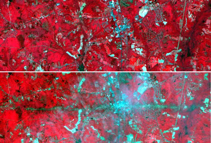
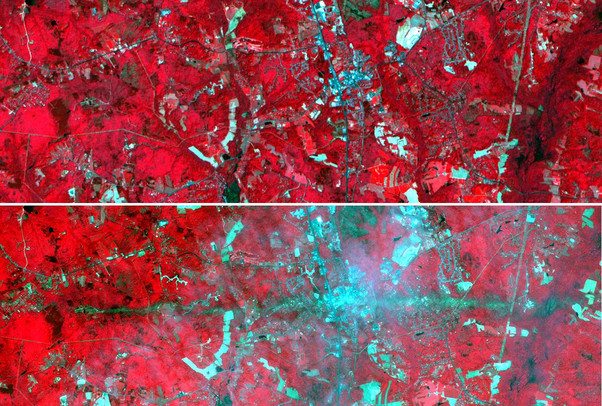
On Sunday, April 28, a category F5 tornado cut an East-West path through La Plata, Maryland, killing 5 and injuring more than 100. These two images acquired by NASA's Terra satellite Advanced Spaceborne Thermal Emission and Reflection Radiometer (ASTER) show a 6-by-17.8-kilometer (3.7-by-11.1-mile) area centered on the town. The top image was acquired on May 12, 2001, and the bottom on May 3, 2002. The bands used for the image portray vegetation in red, and bare fields and urban areas in blue-green. The dark turquoise swath cutting across the 2002 image is the track of the tornado, where the vegetation was ripped up and removed.
With its 14 spectral bands from the visible to the thermal infrared wavelength region, and its high spatial resolution of 15 to 90 meters (about 50 to 300 feet), ASTER will image Earth for the next six years to map and monitor the changing surface of our planet.
ASTER is one of five Earth-observing instruments launched December 18, 1999, on NASA's Terra satellite. The instrument was built by Japan's Ministry of Economy, Trade and Industry. A joint U.S./Japan science team is responsible for validation and calibration of the instrument and the data products. Dr. Anne Kahle at NASA's Jet Propulsion Laboratory, Pasadena, Calif., is the U.S. science team leader; Bjorn Eng of JPL is the project manager. The Terra mission is part of NASA's Earth Science Enterprise, a long-term research effort dedicated to understanding and protecting our home planet. Through the study of Earth, NASA will help to provide sound science to policy and economic decision makers so as to better life here, while developing the technologies needed to explore the universe and search for life beyond our home planet.
The broad spectral coverage and high spectral resolution of ASTER will provide scientists in numerous disciplines with critical information for surface mapping and monitoring dynamic conditions and temporal change. Example applications are: monitoring glacial advances and retreats; monitoring potentially active volcanoes; identifying crop stress; determining cloud morphology and physical properties; evaluating wetlands; monitoring thermal pollution; monitoring coral reef degradation; mapping surface temperatures of soils and geology; and measuring surface heat balance.
Size: 6 by 17.8 kilometers (3.7 x 11.1 miles)
Location: 38.4 degrees North latitude, 77.1 degrees West longitude
Orientation: North at top
Image Data: ASTER bands 1, 2 and 3
Original Data Resolution: 15 meters (49.2 feet)
Dates Acquired: May 12, 2001 and May 3, 2002