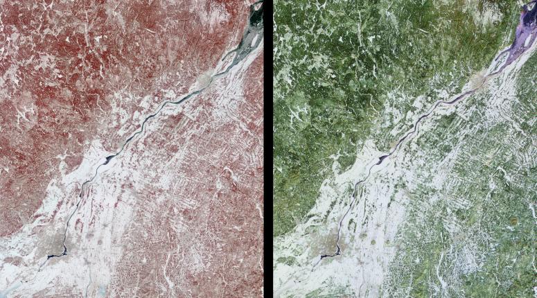
These images of Canada's Québec province were acquired by the Multi-angle Imaging SpectroRadiometer on March 4, 2001. The region's forests are a mixture of coniferous and hardwood trees, and "sugar-shack" festivities are held at this time of year to celebrate the beginning of maple syrup production. The large river visible in the images is the northeast-flowing St. Lawrence. The city of Montréal is located near the lower left corner, and Québec City, at the upper right, is near the mouth of the partially ice-covered St. Lawrence Seaway.
Both spectral and angular information are retrieved for every scene observed by MISR. The left-hand image was acquired by the instrument's vertical-viewing (nadir) camera, and is a false-color spectral composite from the near-infrared, red, and blue bands. The right-hand image is a false-color angular composite using red band data from the 60-degree backward-viewing, nadir, and 60-degree forward-viewing cameras. In each case, the individual channels of data are displayed as red, green, and blue, respectively.
Much of the ground remains covered or partially covered with snow. Vegetation appears red in the left-hand image because of its high near-infrared brightness. In the multi-angle composite, vegetated areas appear in shades of green because they are brighter at nadir, possibly as a result of an underlying blanket of snow which is more visible from this direction. Enhanced forward scatter from the smooth water surface results in bluer hues, whereas urban areas look somewhat orange, possibly due to the effect of vertical structures which preferentially backscatter sunlight.
The data were acquired during Terra orbit 6441, and cover an area measuring 275 kilometers x 310 kilometers.
MISR was built and is managed by NASA's Jet Propulsion Laboratory, Pasadena, CA, for NASA's Office of Earth Science, Washington, DC. The Terra satellite is managed by NASA's Goddard Space Flight Center, Greenbelt, MD. JPL is a division of the California Institute of Technology.