- Original Caption Released with Image:
-
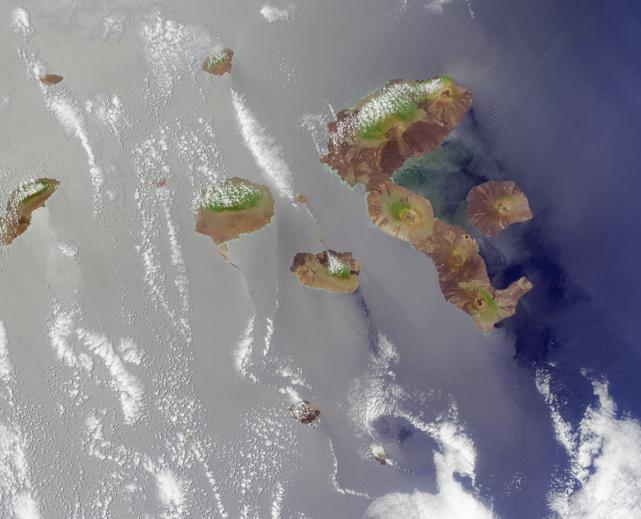
Here's another chance to play geographical detective! This Multi-angle Imaging SpectroRadiometer (MISR) image covers an area measuring approximately 320 kilometers x 260 kilometers, and was captured by the instrument's vertical-viewing (nadir) camera on October 26, 2001. NOTE: To make identification of this scene more difficult, the image has been rotated such that north is not necessarily at the top.Below are nine statements about the islands highlighted in this image. Use any reference materials you like, and mark each statement true or false:1. There are no endemic species of cactus on any of the islands.2. Flamingos, whose diets include crustaceans, tiny fish, and algae, can be found wading in brackish lagoons.3. A change in ocean temperature associated with an episodic disruption in atmospheric circulation led to a precipitous decline in the local penguin population.4. Discovery of the islands is generally attributed to a 16th century Spanish missionary whose vessel veered off its intended course.5. A recurring and dramatic geological event took place on the westernmost island in 1988, 1991 and 1995, causing injury or death to over 2,000 people.6. Several plant species are endangered due to decimation by goats and competition with non-native vegetation.7. Within the archipelago there are at least half a dozen freshwater lakes with diameters exceeding 250 meters.8. A particular endangered animal sub-species is survived by a single male, and attempts at breeding have so far proved unsuccessful.9. Chapter 13 of a book written in the mid-nineteenth century by a native of Shrewsbury, England is primarily concerned with the islands of this archipelago.E-mail your answers, name (initials are acceptable if you prefer), and your hometown by Tuesday, December 18, 2001 to suggestions@mail-misr.jpl.nasa.gov.Answers will be published on the MISR Quiz page in conjunction with the next weekly image release. The names and home towns of respondents who answer all questions correctly by the deadline will also be published in the order responses were received. The first 3 people on this list who are not affiliated with NASA, JPL, or MISR and who did not win a prize in the last quiz will be sent a print of the image.A new "Where on Earth...?" mystery appears as the MISR "image of the week" approximately once per month. A new image of the week is released every Wednesday at noon Pacific time on the MISR home page http://www-misr.jpl.nasa.gov. The image also appears on the Earth Observatory, http://Earthobservatory.nasa.gov/, and on the Atmospheric Sciences Data Center home page, http://eosweb.larc.nasa.gov/, though usually with a several-hour delay.MISR was built and is managed by NASA's Jet Propulsion Laboratory, Pasadena, CA, for NASA's Office of Earth Science, Washington, DC. The Terra satellite is managed by NASA's Goddard Space Flight Center, Greenbelt, MD. JPL is a division of the California Institute of Technology.
- Image Credit:
-
NASA/GSFC/LaRC/JPL, MISR Team
Image Addition Date: -
2001-12-12
|