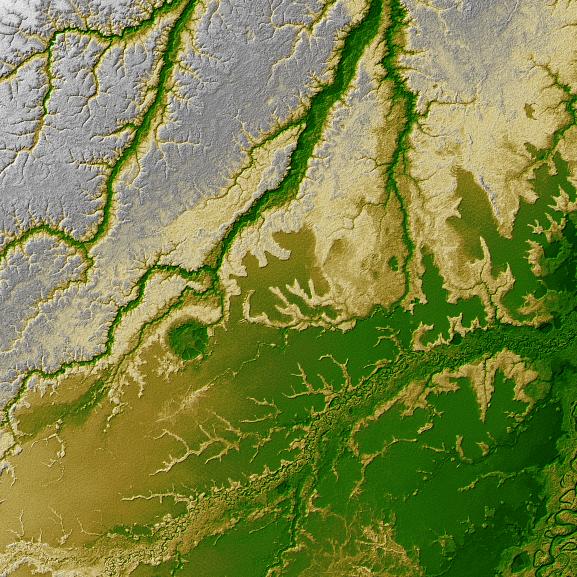
An 8-kilometer (5-mile) wide crater of possible impact origin is shown in this view of an isolated part of the Bolivian Amazon from the Shuttle Radar Topography Mission. The circular feature at the center-left of the image, known as the Iturralde Structure, is possibly the Earth's most recent "big" impact event recording collision with a meteor or comet that might have occurred between 11,000 and 30,000 years ago.
Although the structure was identified on satellite photographs in the mid-1980s, its location is so remote that it has only been visited by scientific investigators twice, most recently by a team from NASA's Goddard Space Flight Center in September 2002. Lying in an area of very low relief, the landform is a quasi-circular closed depression only about 20 meters (66 feet) in depth, with sharply defined sub-angular "rim" materials. It resembles a "cookie cutter" in that its appearance "cuts" the heavily vegetated soft-sediments and pampas of this part of Bolivia. The SRTM data have provided investigators with the first topographic map of the site and will allow studies of its three-dimensional structure crucial to determining whether it actually is of impact origin.
Two visualization methods were combined to produce this image: shading and color coding of topographic height. The shade image was derived by computing topographic slope in the northwest-southeast direction. North-facing slopes appear bright and south-facing slopes appear dark. Color coding is directly related to topographic height, with brown and green at the lower elevations, rising through yellow and brown to white at the highest elevations.
Elevation data used in this image was acquired by the Shuttle Radar Topography Mission aboard Space Shuttle Endeavour, launched on Feb. 11, 2000. The mission used the same radar instrument that comprised the Spaceborne Imaging Radar-C/X-Band Synthetic Aperture Radar (SIR-C/X-SAR) that flew twice on Endeavour in 1994. The Shuttle Radar Topography Mission was designed to collect 3-D measurements of Earth's surface. To collect the 3-D data, engineers added a 60-meter (approximately 200-foot) mast, installed additional C-band and X-band antennas, and improved tracking and navigation devices. The mission is a cooperative project between NASA, the National Imagery and Mapping Agency (NIMA) of the U.S. Department of Defense, and the German and Italian space agencies. It is managed by NASA's Jet Propulsion Laboratory, Pasadena, Calif., for NASA's Earth Science Enterprise, Washington, D.C.
Size: 1 degree latitude by 1 degree longitude (about 111 by 111 kilometers or 69 by 69 miles)
Location: 12.5 degrees South latitude, 67.5 degrees West longitude
Orientation: North at top
Image: Elevation data, colored height with shaded relief
Original Data Resolution: SRTM 1 arcsecond (about 30 meters or 98 feet)
Date Acquired: February 2000 (SRTM)
 Planetary Data System


