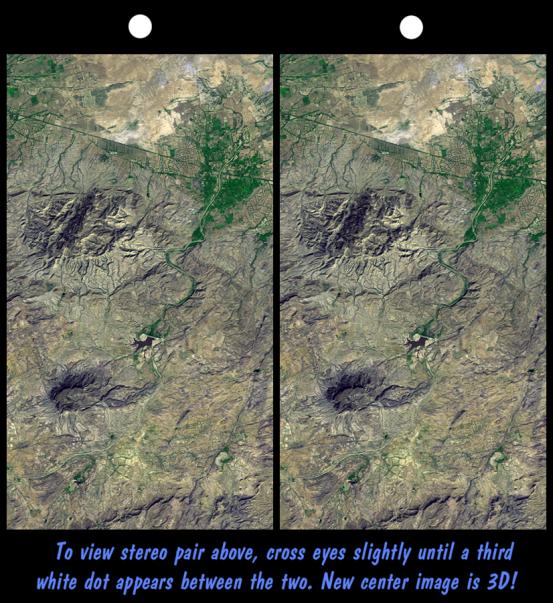
On January 26, 2001, the Kachchh region in western India suffered the most deadly earthquake in India's history. Shortly thereafter, geologists traversed the region looking for ground surface disruptions, such as fault breaks, that could provide clues to the tectonic processes here. Shuttle Radar Topography Mission (SRTM) scientists provided stereoscopic images to the geologists, similar to this 3-D view of the terrain northwest of the city of Bhuj. The geologists reported back that the images were essential in optimizing their field activities. Tectonic landforms are created by ground displacements that are repetitious over geologic time, so these landforms are good places to look for co-seismic faulting and warping. The stereoscopic images showed the geologists where the structures are located and their overall pattern, which could not be seen while standing on anyone hill or in any one gully. In general, the field studies found that surface disruptions by the recent earthquake were minimal and that the major landforms are quite old and probably not directly related to ongoing tectonic processes.
Features of interest in the view shown here include the largest hill (upper left-center), which is a dome or anticline, upwardly convex layered rocks. Also visible are a possible volcanic plug (lower left-center) and an incised meandering stream (center). Agriculture in this arid region is concentrated on the alluvial fan of the major stream (green pattern, upper right).
This stereoscopic image was generated by draping a Landsat satellite image (taken just two weeks after the earthquake) over a preliminary SRTM elevation model. Two differing perspectives were then calculated, one for each eye. They can be seen in 3-D by viewing the left image with the right eye and the right image with the left eye (cross-eyed viewing or by downloading and printing the image pair and viewing them with a stereoscope. When stereoscopically merged, the result is a vertically exaggerated view of Earth's surface in its full three dimensions.
Landsat has been providing visible and infrared views of Earth since 1972. SRTM elevation data matches the 30-meter (33-yard) resolution of most Landsat images and will substantially help in analyses of the large and growing Landsat image archive. The Landsat 7 Thematic Mapper image used here was provided to the SRTM project by the United States Geological Survey, Earth Resources Observation Systems (EROS) Data Center, Sioux Falls, South Dakota.
Elevation data used in this image was acquired by the Shuttle Radar Topography Mission aboard Space Shuttle Endeavour, launched on February 11, 2000. SRTM used the same radar instrument that comprised the Spaceborne Imaging Radar-C/X-Band Synthetic Aperture Radar (SIR-C/X-SAR) that flew twice on Space Shuttle Endeavour in 1994. SRTM was designed to collect three-dimensional measurements of Earth's surface. To collect the 3-D data, engineers added a 60-meter-long (200-foot) mast, installed additional C-band and X-band antennas, and improved tracking and navigation devices. The mission is a cooperative project between the National Aeronautics and Space Administration (NASA), the National Imagery and Mapping Agency (NIMA) of the U.S. Department of Defense (DoD), and the German and Italian space agencies. It is managed by NASA's Jet Propulsion Laboratory, Pasadena, CA, for NASA's Earth Science Enterprise, Washington, DC.
Size: 21.3 x 11.9 kilometers (13.2 x 7.4 miles)
Location: 23.4 deg. North lat., 69.6 deg. East lon.
Orientation: North toward the top
Image Data: Landsat Bands 1, 2+4, 3 as blue, green, red, respectively
Date Acquired: February 2000 (SRTM), February 9, 2001 (Landsat)