Mars Global Surveyor (MGS) was launched from Earth just over five years ago on November 7, 1996. It began to orbit Mars on September 12, 1997. After slightly more than four years in orbit, we have now received our 100,000th image from the MGS Mars Orbiter Camera (MOC). For comparison, the Viking 1 and Viking 2 orbiters together returned ~55,000 images during the time they were operational from 1976 to 1980. The Vikings returned about 70 Gbytes of data; MOC has returned 163 Gbytes (after decompression).
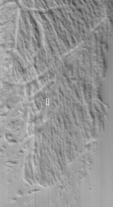
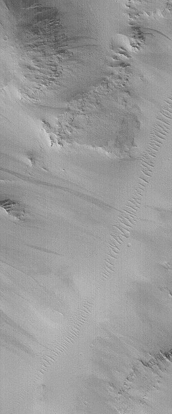
MOC's 100,000th image was received on November 5, 2001. Its context frame (below) was received at the same time. The 100,000th image is located near 24.2°N, 127.4°W, in Cyane Sulci, a grouping of ridges northeast of the giant volcano, Olympus Mons. This image shows a valley running diagonally from near the upper right to the lower left, the floor of which is covered by windblown dunes. The slopes on either side of the valley show dark streaks of debris that have slid down from the surrounding ridges. The image has fairly low contrast and a streaked appearance because the atmosphere of Mars was still somewhat hazy following a series of large dust storms that nearly obscured the planet between July and October 2001. Both images are illuminated from the lower left, the high resolution view (above) covers an area 1.5 km (0.9 mi) across, the context view (with white box to indicate location of high resolution view) covers an area 63 km (39 mi) across.
To date, more than two-thirds of all MOC images, covering the first year and a half of pre-mapping operations and the first full Mars year of mapping, have been carefully examined, validated, cataloged, and archived with the NASA Planetary Data System (PDS). To view these first 78,000+ MOC images, visit the MOC Gallery. Work is on-going to similarly process data being collected during the "extended mission" presently underway, which will be archived in future deliveries to the PDS.
 Planetary Data System


