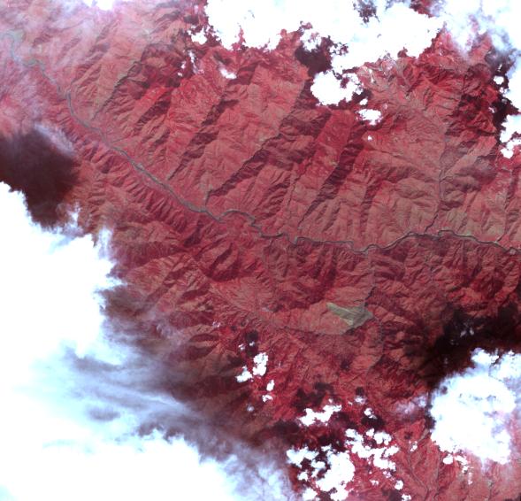
This image acquired by the Advanced Spaceborne Thermal Emission and Reflection Radiometer on NASA's Terra spacecraft on October 11, 2005, depicts a 30-kilometer (19-mile) wide region southeast of the epicenter of the magnitude 7.6 Pakistan earthquake on October 8, 2005, between Muzaffarabad and Uri in the Pir Punjal range of Kashmir. The center of the image is at about 34 degrees, 13 minutes North; 73 degrees, 42 minutes East. A large landslide is visible (brown color) to the south of the main river (Jhelum River) crossing the image. The landslide appears to have blocked the flow of a small river. A number of smaller landslides are also visible, mostly along the main river and other valleys. For a 3D perspective view of this image, see PIA03030.
ASTER is one of five Earth-observing instruments launched December 18, 1999, on NASA's Terra satellite. The instrument was built by Japan's Ministry of Economy, Trade and Industry. A joint U.S./Japan science team is responsible for validation and calibration of the instrument and the data products.
The broad spectral coverage and high spectral resolution of ASTER provides scientists in numerous disciplines with critical information for surface mapping, and monitoring of dynamic conditions and temporal change. Example applications are: monitoring glacial advances and retreats; monitoring potentially active volcanoes; identifying crop stress; determining cloud morphology and physical properties; wetlands evaluation; thermal pollution monitoring; coral reef degradation; surface temperature mapping of soils and geology; and measuring surface heat balance.
The U.S. science team is located at NASA's Jet Propulsion Laboratory, Pasadena, Calif. The Terra mission is part of NASA's Science Mission Directorate.
Size: 29.0 x 27.9 km (18.0 x 17.3 miles)
Location: 34.149 degrees North latitude, 73.712 degrees East longitude
Orientation: North about 10 degrees to left of up
Image Data: ASTER bands 1, 2, and 3
Original Data Resolution: 15 m (49.2 feet)
Date Acquired: October 11, 2005