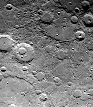
Mariner 10 obtained this picture (FDS 166619) of an area 460 by 640 kilometers (285 by 400 miles) in the Southern hemisphere of Mercury during its second encounter with the planet on September 21, 1974. Taken from a distance of 78,000 kilometers (48,000 miles), the photo reveals a heavily cratered terrain with a prominent scrap extending several hundred kilometers across the upper left. A 40-kilometer-diameter (25 miles) crater, nested in a larger crater, 120 kilometers (75 miles), is at top center. A basin about 240 kilometers (15 miles) in diameter is barely discernible at lower right. Crater chains produced by material ejected from a larger crater located outside the field of view appear at lower left. The smallest details measure about 1.7 kilometers (one mile).
The Mariner 10 mission, managed by the Jet Propulsion Laboratory for NASA's Office of Space Science, explored Venus in February 1974 on the way to three encounters with Mercury-in March and September 1974 and in March 1975. The spacecraft took more than 7,000 photos of Mercury, Venus, the Earth and the Moon.