The most familiar reference system for locating places on the surface of a planetary body is latitude and longitude. On a spherical body like Earth, these measures have a comfortable, predictable feel to them - despite the difficulty in showing a spherical planet on a flat map. However, the irregular peanut-like shape of Eros lends the asteroid's latitude-longitude grid a surprising character.
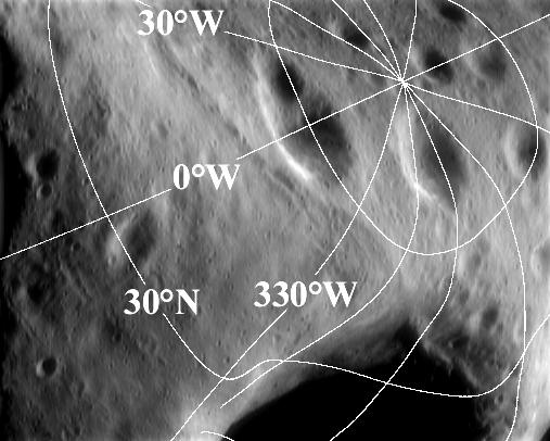
This image of the north polar region was taken from NEAR Shoemaker March 31, 2000, from an orbital altitude of 207 kilometers (129 miles). The image has been overlain with lines of latitude and longitude. Latitude is measured in degrees from the equator to the pole; longitude is measured in degrees west of a "prime meridian." In both cases, the vertex of the angle being measured is the center of Eros. The wandering, curved shapes of the lines are caused by the highly nonspherical and irregular asteroid shape.
Built and managed by The Johns Hopkins University Applied Physics Laboratory, Laurel, Maryland, NEAR was the first spacecraft launched in NASA's Discovery Program of low-cost, small-scale planetary missions. See the NEAR web page at http://near.jhuapl.edu/ for more details.