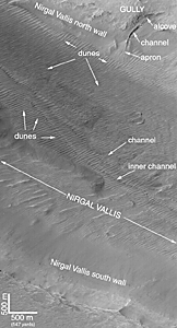
Release image with labels | 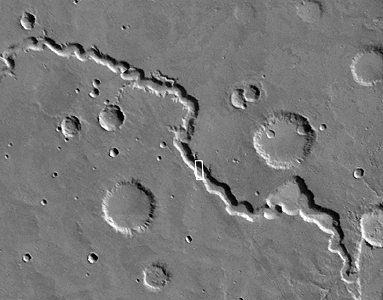
Context Image |
The Mars Global Surveyor (MGS) Mars Orbiter Camera (MOC) has found that only two ancient martian valleys contain evidence for sustained fluid flow. The first was Nanedi Valles--this finding was announced back in February 1998 (See: Nanedi Vallis: Sustained Water Flow?). When this picture was obtained in September 1999, Nirgal Vallis joined the lonely list with Nanedi Valles. But Nirgal is different--it also contains evidence for much more recent fluid seepage from its walls!The context view on the right--a mosaic of Viking orbiter views from the U.S. Geological Survey--shows the location (white box) of the high resolution MOC view on the left. The MOC image shows two channels running through the center of Nirgal Vallis--a wide, outer channel with a narrow, leveed "inner channel" running down its center. Leveed refers to the fact that the inner channel's walls appear to be raised above the surrounding terrain, like a levee that might be used to protect property from floods on the Mississippi River. Levees can form naturally from running water or lava... it is not clear which fluid--lava or water--was involved in Nirgal Vallis.
The wall of Nirgal Vallis shows something else--a much more recent "gully" with an alcove at the top of the slope, a channel, and an apron that partly covers some of the adjacent sand dunes. This gully is inferred to be much younger than the channels running down the center of Nirgal Vallis, because these channels are covered by dunes, while the gully's apron covers the dunes. This gully feature is one of many reported by MGS MOC scientists in June 2000 as being the possible result of geologically recent groundwater seepage and mud or debris flow. (See: MOC Images Suggest Recent Sources of Liquid Water on Mars).
The image is located near 29.4°S, 39.1°W. North is toward the upper right and illumination is from the upper left. Aspect ratio is 1.5:1, thus the scale bar in the labeled image (middle) shows different vertical and horizontal scales. The picture covers an area 3 km (1.9 mi) by 6.5 km (4 mi) and is a subframe of M07-00752. To see what the raw MOC image data look like, visit the newest data releases (for Mission Subphases M07 - M12, covering September 1999 through February 2000) in the MOC GALLERY.


