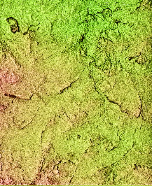
Located north of the Swartberg Mountains in South Africa's Northern Cape Province, this topographic image shows a portion of the Great Karoo region. Karoo is an indigenous word for "dry thirst land." The semi-arid area is known for its unique variety of flora and fauna. The topography of the area, with a total relief of 200 meters (650 feet), reveals much about the geologic history of the area. The linear features seen in the image are near-vertical walls of once-molten rock, or dikes, that have intruded the bedrock. The dikes are more resistant to weathering and, therefore, form the linear wall-like features seen in the image. In relatively flat arid areas such as this, small changes in the topography can have large impacts on the water resources and the local ecosystem. These data can be used by biologists to study the distribution and range of the different plants and animals. Geologists can also use the data to study the geologic history of this area in more detail.
This shaded relief image was generated using topographic data from the Shuttle Radar Topography Mission. A computer-generated artificial light source illuminates the elevation data to produce a pattern of light and shadows. Slopes facing the light appear bright, while those facing away are shaded. On flatter surfaces, the pattern of light and shadows can reveal subtle features in the terrain. Colors show the elevation as measured by SRTM. Colors range from green at the lowest elevations to reddish at the highest elevations. Shaded relief maps are commonly used in applications such as geologic mapping and land use planning.
The Shuttle Radar Topography Mission (SRTM), launched on February 11, 2000, uses the same radar instrument that comprised the Spaceborne Imaging Radar-C/X-Band Synthetic Aperture Radar (SIR-C/X-SAR) that flew twice on the Space Shuttle Endeavour in 1994. The mission is designed to collect three-dimensional measurements of the Earth's surface. To collect the 3-D data, engineers added a 60-meter-long (200-foot) mast, an additional C-band imaging antenna and improved tracking and navigation devices. The mission is a cooperative project between the National Aeronautics and Space Administration (NASA), the National Imagery and Mapping Agency (NIMA) and the German (DLR) and Italian (ASI) space agencies. It is managed by NASA's Jet Propulsion Laboratory, Pasadena, CA, for NASA's Earth Science Enterprise, Washington, DC.