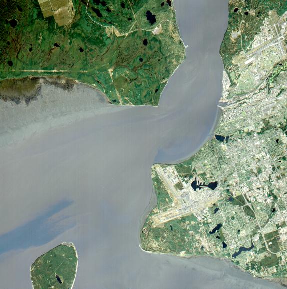
Anchorage, Alaska and Cook Inlet are seen in this 30 by 30 km (19 by 19 miles) sub-image, acquired May 12, 2000 by the Advanced Spaceborne Thermal Emission and Reflection Radiometer (ASTER). Orbiting at an altitude of 705 km (430 miles) on board NASA's Terra satellite, ASTER provides data at a resolution of 15 m (47 feet) and allows creation of this simulated natural color image. At the center of the image is the Ted Stevens Anchorage International Airport; in the upper right corner is Elmendorf Air Force Base. Dark green coniferous forests are seen in the northwest part of the image. A golf course, with its lush green fairways, is just south of the Air Force Base.
The image covers an area of 30 by 30 km, was acquired May 12, 2000, and is located at 61.2 degrees north latitude and 149.9 degrees west longitude.
Advanced Spaceborne Thermal Emission and Reflection Radiometer (ASTER) is one of five Earth-observing instruments launched December 18, 1999, on NASA's Terra satellite. The instrument was built by Japan's Ministry of International Trade and Industry. A joint U.S./Japan science team is responsible for validation and calibration of the instrument and the data products. Dr. Anne Kahle at NASA's Jet Propulsion Laboratory, Pasadena, California, is the U.S. science team leader; Moshe Pniel of JPL is the project manager. ASTER is the only high-resolution imaging sensor on Terra. The primary goal of the ASTER mission is to obtain high-resolution image data in 14 channels over the entire land surface, as well as black and white stereo images. With revisit time of between 4 and 16 days, ASTER will provide the capability for repeat coverage of changing areas on Earth's surface.
The broad spectral coverage and high spectral resolution of ASTER will provide scientists in numerous disciplines with critical information for surface mapping and monitoring dynamic conditions and temporal change. Examples of applications include monitoring glacial advances and retreats, potentially active volcanoes, thermal pollution, and coral reef degradation; identifying crop stress; determining cloud morphology and physical properties; evaluating wetlands; mapping surface temperature of soils and geology; and measuring surface heat balance.