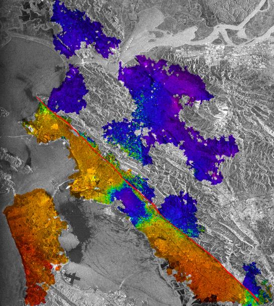
This image of California's Hayward fault is an interferogram created using a pair of images taken by Synthetic Aperture Radar (SAR) combined to measure changes in the surface that may have occurred between the time the two images were taken.
The images were collected by the European Space Agency's Remote Sensing satellites ERS-1 and ERS-2 in June 1992 and September 1997 over the central San Francisco Bay in California.
The radar image data are shown as a gray-scale image, with the interferometric measurements that show the changes rendered in color. Only the urbanized area could be mapped with these data. The color changes from orange tones to blue tones across the Hayward fault (marked by a thin red line) show about 2-3centimeters (0.8-1.1 inches) of gradual displacement or movement of the southwest side of the fault. The block west of the fault moved horizontally toward the northwest during the 63 months between the acquisition of the two SAR images. This fault movement is called a seismic creep because the fault moved slowly without generating an earthquake.
Scientists are using the SAR interferometry along with other data collected on the ground to monitor this fault motion in an attempt to estimate the probability of earthquake on the Hayward fault, which last had a major earthquake of magnitude 7 in 1868. This analysis indicates that the northern part of the Hayward fault is creeping all the way from the surface to a depth of 12 kilometers (7.5 miles). This suggests that the potential for a large earthquake on the northern Hayward fault might be less than previously thought. The blue area to the west (lower left) of the fault near the center of the image seemed to move upward relative to the yellow and orange areas nearby by about 2 centimeters (0.8 inches). The cause of this apparent motion is not yet confirmed, but the rise of groundwater levels during the time between the images may have caused the reversal of a small portion of the subsidence that this area suffered in the past.
This research is the result of collaboration between the University of California's Berkeley and Davis campuses, the Lawrence Berkeley National Laboratory, and NASA's Jet Propulsion Laboratory in Pasadena, Calif. and is reported in the August 18, 2000, issue of Science magazine.