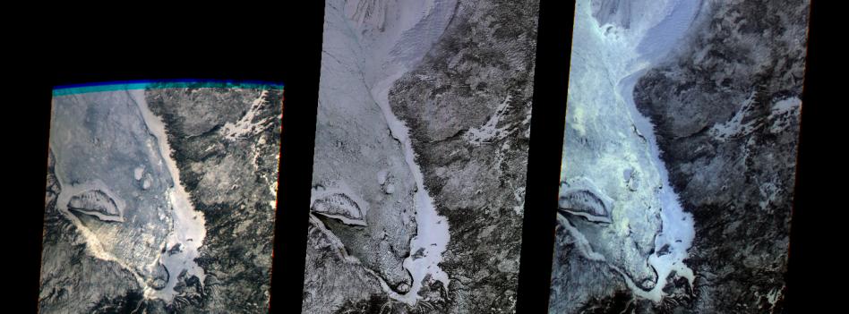
The first images taken by NASA's Multi-angle Imaging SpectroRadiometer (MISR) on February 24, 2000, show the winter landscape of James Bay, Ontario, Canada from three of the instrument's nine cameras. The image at left captures the opening of MISR's cover and was recorded by the most oblique forward-viewing camera, which images the Earth at 70 degrees relative to a vertical plane. Several islands, including the crescent-shaped Akimiski Island, are visible in the frozen bay. The center image was acquired a few minutes later by the "nadir" camera, which looks straight down. The image on the right was taken seven minutes after the first image from the most oblique, aftward-viewing camera.
"These first pictures illustrate many of MISR's new and unique capabilities," said Dr. David J. Diner, MISR principal investigator of NASA's Jet Propulsion Laboratory, Pasadena, CA. "The instrument, operations system, and science data processing software are performing extremely well and the quality of the images, particularly at the very challenging oblique angles, is outstanding."
An increased blue tint at the oblique angles is the result of scattering of light in the atmosphere. Contrast reversals and other color and brightness variations from one angle to another are also apparent, and are most likely due to varied surface geometries and textures. Observing such changes in image content and detail from space over a wide range of angles, almost simultaneously, is a novel approach for characterizing surface, atmospheric, and cloud characteristics. The MISR data will continue to provide unprecedented details about Earth's climate over the next six years. Capturing long, ribbon-like images, 400 kilometers (250 miles) wide, MISR can detect objects as small as 275 meters (900 feet) in diameter.
The MISR instrument is managed by NASA's Jet Propulsion Laboratory for NASA's Office of Earth Science, Washington, DC. MISR is flying on the Terra satellite, which is managed by NASA's Goddard Space Flight Center, Greenbelt, MD.