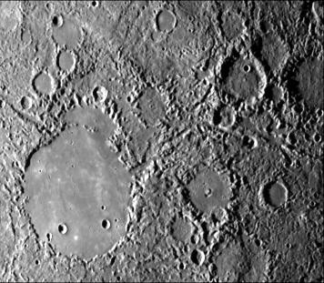
Hilly and lineated terrain and a patch of smooth plains in a large degraded crater (lower left portion of the image). Linear scalloped valleys extend mostly NW from the center (e.g., Arecibo Vallis); some trend NNE. Small craters are rare in the terrain; most landforms are positive. Area centered at 28 degrees S, 22 degrees W measures 450 km across. Mariner 10 frame 27370 taken during the spacecraft's first encounter with Mercury.
The Mariner 10 mission, managed by the Jet Propulsion Laboratory for NASA's Office of Space Science, explored Venus in February 1974 on the way to three encounters with Mercury-in March and September 1974 and in March 1975. The spacecraft took more than 7,000 photos of Mercury, Venus, the Earth and the Moon.