The magnitude 9.2 Indian Ocean earthquake of December 26, 2004, produced broad regions of uplift and subsidence. In order to define the lateral extent and the downdip limit of rupture, scientists from Caltech, Pasadena, Calif.; NASA's Jet Propulsion Laboratory, Pasadena, Calif.; Scripps Institution of Oceanography, La Jolla, Calif.; the U.S. Geological Survey, Pasadena, Calif.; and the Research Center for Geotechnology, Indonesian Institute of Sciences, Bandung, Indonesia; first needed to define the pivot line separating those regions. Interpretation of satellite imagery and a tidal model were one of the key tools used to do this.
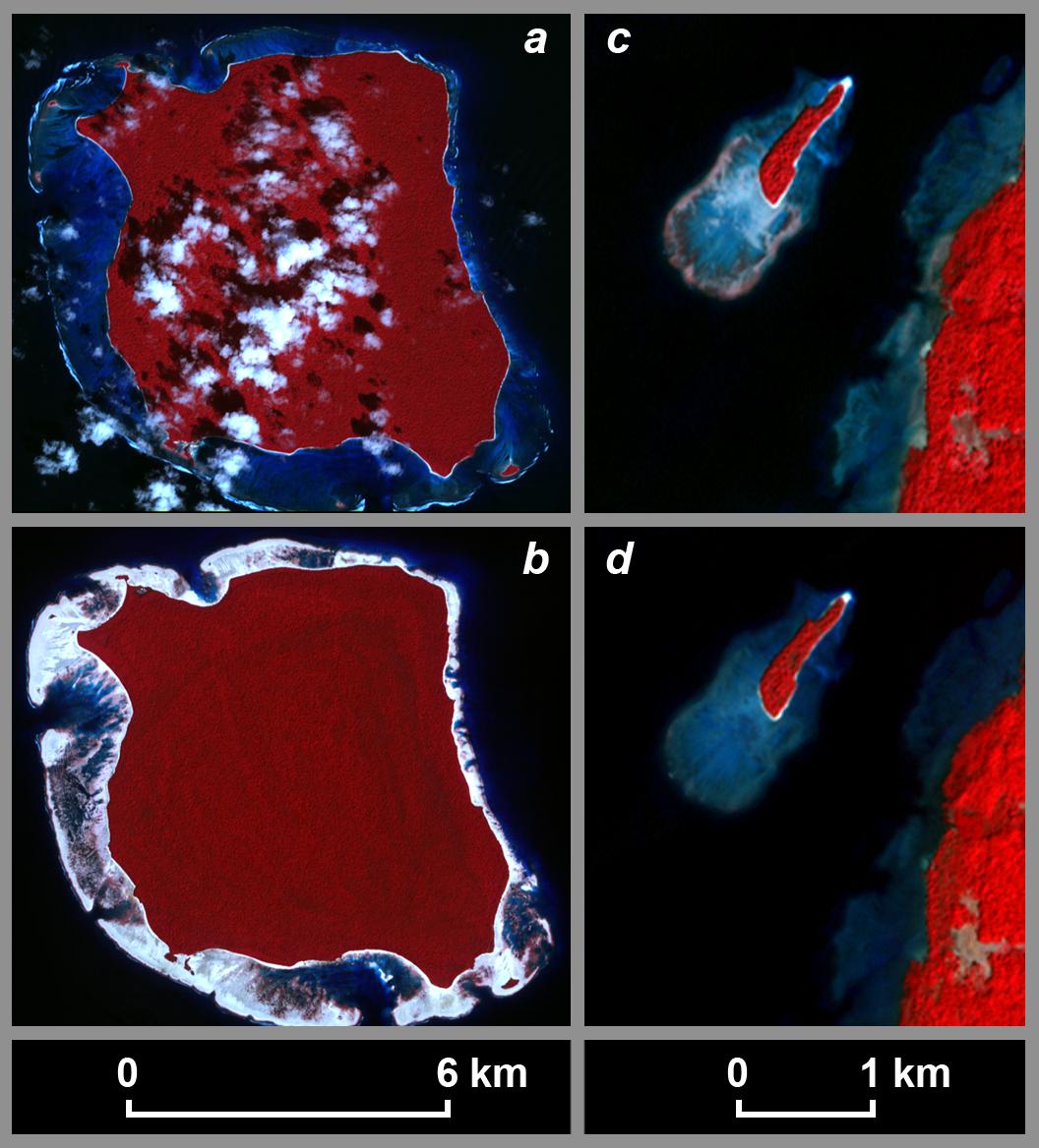
These pre-Sumatra earthquake (a) and post-Sumatra earthquake (b) images of North Sentinel Island in the Indian Ocean, acquired from the Advanced Spaceborne Thermal Emission and Reflection Radiometer (ASTER) instrument on NASA's Terra spacecraft, show emergence of the coral reef surrounding the island following the earthquake. The tide was 30 plus or minus 14 centimeters lower in the pre-earthquake image (acquired November 21, 2000) than in the post-earthquake image (acquired February 20, 2005), requiring a minimum of 30 centimeters of uplift at this locality. Observations from an Indian Coast Guard helicopter on the northwest coast of the island suggest that the actual uplift is on the order of 1 to 2 meters at this site.
In figures (c) and (d), pre-earthquake and post-earthquake ASTER images of a small island off the northwest coast of Rutland Island, 38 kilometers east of North Sentinel Island, show submergence of the coral reef surrounding the island. The tide was higher in the pre-earthquake image (acquired January 1, 2004) than in the post-earthquake image (acquired February 4, 2005), requiring subsidence at this locality. The pivot line must run between North Sentinel and Rutland islands. Note that the scale for the North Sentinel Island images differs from that for the Rutland Island images.
The tidal model used for this study was based on data from JPL's Topex/Poseidon satellite. The model was used to determine the relative sea surface height at each location at the time each image was acquired, a critical component used to quantify the deformation.
The scientists' method of using satellite imagery to recognize changes in elevation relative to sea surface height and of using a tidal model to place quantitative bounds on coseismic uplift or subsidence is a novel approach that can be adapted to other forms of remote sensing and can be applied to other subduction zones in tropical regions.
ASTER is one of five Earth-observing instruments launched December 18, 1999, on NASA's Terra satellite. The instrument was built by Japan's Ministry of Economy, Trade and Industry. A joint U.S./Japan science team is responsible for validation and calibration of the instrument and the data products.
The broad spectral coverage and high spectral resolution of ASTER provides scientists in numerous disciplines with critical information for surface mapping, and monitoring of dynamic conditions and temporal change. Example applications are: monitoring glacial advances and retreats; monitoring potentially active volcanoes; identifying crop stress; determining cloud morphology and physical properties; wetlands evaluation; thermal pollution monitoring; coral reef degradation; surface temperature mapping of soils and geology; and measuring surface heat balance.
The U.S. science team is located at NASA's Jet Propulsion Laboratory, Pasadena, Calif. The Terra mission is part of NASA's Science Mission Directorate.
