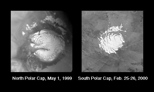
The portion of each martian polar cap that remains frosted through the summer is known as the Residual Polar Cap. It is also sometimes called the Permanent Polar Cap, although from one summer to the next the amount of frost that remains might vary.
The two pictures above show examples of the north and south polar residual caps as they appeared in summer. The pictures are small because they have been extracted from the daily global maps taken by the Red Wide Angle Camera of the Mars Orbiter Camera (MOC) system onboard the Mars Global Surveyor (MGS) orbiter. On every orbit, a tiny picture showing a portion of Mars at a resolution of 7.5 kilometers (4.7 miles) per pixel is obtained so that the changing martian weather--and changing polar caps--can be monitored.
The latest northern hemisphere summer season ended the first of August 1999. Thus, the picture shown above (left) presents what the north polar residual cap looked like during the most recent summer. As for southern summer, it began around December 25, 1999, and continues today. The picture shown here (above, right) indicates what the south polar residual cap looked like near the end of February 2000.
These two images have been used as planning tools by the MOC team at MSSS. The "pinwheel" pattern in the south polar picture is being shown on purpose. The pattern results from the fact that the south polar picture is a mosaic of more than 12 global images acquired by MOC on February 25 and 26, 2000. Mosaics such as this are used every week by the team for targeting purposes (to see which areas are covered by frost). This particular mosaic was used for planning MOC high resolution views during the first few days of March 2000. The north polar image does not show seams because this picture was extracted from a single daily global image that was map-projected and used by the MOC team and used for weather monitoring.
To see an example of the MGS MOC "daily global map"--one acquired in April 1999--see:"Mars Global Weather Monitoring," July 19, 1999.
Malin Space Science Systems and the California Institute of Technology built the MOC using spare hardware from the Mars Observer mission. MSSS operates the camera from its facilities in San Diego, CA. The Jet Propulsion Laboratory's Mars Surveyor Operations Project operates the Mars Global Surveyor spacecraft with its industrial partner, Lockheed Martin Astronautics, from facilities in Pasadena, CA and Denver, CO.