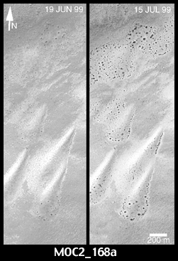
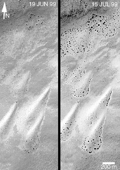
As the retreat of the south polar winter frost cap became visible in June 1999, high resolution images from the Mars Global Surveyor (MGS) Mars Orbiter Camera (MOC) began to show dark spots forming on the surfaces of frost-covered sand dunes. Immediately, the MOC science team began to plan to observe several dune fields more than once, should that opportunity arise, so that the evolution of these dark spots could be documented and studied. Such work will eventually lead to abetter understanding of how the martian polar caps retreat as winter ends and spring unfolds in each hemisphere.
MGS is in a polar orbit, which means that, unlike many other places on Mars, the spacecraft has more opportunities to take pictures of the same place. Dune fields near 87° latitude can be repeatedly viewed; dunes near the equator are not likely to be photographed more than once during the entire MGS mission.
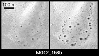
The pictures presented here show changes on a set of nearly pear-shaped sand dunes located on the floor of an unnamed crater at 59°S, 353°W. The picture on the left shows the dunes as they appeared on June 19, 1999, the picture on the right shows the same dunes on July 15, 1999. The dark spots in the June 19picture -- indicating areas where frost has sublimed away -- became larger by July 15th. In addition, new spots had appeared as of mid-July. If possible, these dunes will be photographed by MOC again in mid-August and each month until the frost is gone.
The pictures shown in (B) (above) are expanded views of portions of the pictures in (A). The 200 meter scale bar equals 656 feet; the 100 meter bar is 328 feet (109 yards) long. All images are illuminated from the upper left; north is toward the upper right.
Malin Space Science Systems and the California Institute of Technology built the MOC using spare hardware from the Mars Observer mission. MSSS operates the camera from its facilities in San Diego, CA. The Jet Propulsion Laboratory's Mars Surveyor Operations Project operates the Mars Global Surveyor spacecraft with its industrial partner, Lockheed Martin Astronautics, from facilities in Pasadena, CA and Denver, CO.
