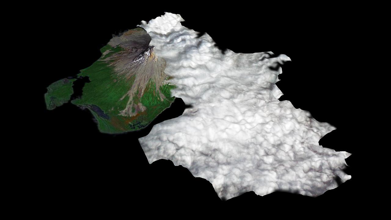
Since last spring, the U.S. Geological Survey's Alaska Volcano Observatory (AVO) has detected increasing volcanic unrest at Augustine Volcano in Cook Inlet, Alaska near Anchorage. Based on all available monitoring data, AVO regards that an eruption similar to 1976 and 1986 is the most probable outcome. During January, activity has been episodic, and characterized by emission of steam and ash plumes, rising to altitudes in excess of 9,000 m (30,000 ft), and posing hazards to aircraft in the vicinity. An ASTER image was acquired at 12:42 AST on January 12, 2006, during an eruptive phase of Augustine. The perspective rendition shows the eruption plume derived from the ASTER image data. ASTER's stereo viewing capability was used to calculate the 3-dimensional topography of the eruption cloud as it was blown to the south by prevailing winds. From a maximum height of 3060 m (9950 ft), the plume cooled and its top descended to 1900 m (6175 ft). The perspective view shows the ASTER data draped over the plume top topography, combined with a base image acquired in 2000 by the Landsat satellite, that is itself draped over ground elevation data from the Shuttle Radar Topography Mission. The topographic relief has been increased 1.5 times for this illustration. Comparison of the ASTER plume topography data with ash dispersal models and weather radar data will allow the National Weather Service to validate and improve such models. These models are used to forecast volcanic ash plume trajectories and provide hazard alerts and warnings to aircraft in the Alaska region.
ASTER is one of five Earth-observing instruments launched December 18, 1999, on NASA's Terra satellite. The instrument was built by Japan's Ministry of Economy, Trade and Industry. A joint U.S./Japan science team is responsible for validation and calibration of the instrument and the data products.
The broad spectral coverage and high spectral resolution of ASTER provides scientists in numerous disciplines with critical information for surface mapping, and monitoring of dynamic conditions and temporal change. Example applications are: monitoring glacial advances and retreats; monitoring potentially active volcanoes; identifying crop stress; determining cloud morphology and physical properties; wetlands evaluation; thermal pollution monitoring; coral reef degradation; surface temperature mapping of soils and geology; and measuring surface heat balance.
The U.S. science team is located at NASA's Jet Propulsion Laboratory, Pasadena, Calif. The Terra mission is part of NASA's Science Mission Directorate.
Size: Roughly 25 km (15 miles) across; scale varies in this perspective view
Location: 59.3 deg. North latitude, 153.4 deg. West longitude
Orientation: View from southwest towards the northeast
Vertical Exaggeration: 2
Eruption plume and Elevation: 30 m ASTER, (1-arcsecond)
Image Data: Landsat bands 7, 4 and 2
Ground Topography Data: SRTM 90 m data, acquired January 2000
Date Acquired: ASTER: January 12, 2006; Landsat: September 17, 2000
