PDS logoPlanetary Data System
PDS Information
Find a Node - Use these links to navigate to any of the 8 publicly accessible PDS Nodes.

This bar indicates that you are within the PDS enterprise which includes 6 science discipline nodes and 2 support nodes which are overseen by the Project Management Office at NASA's Goddard Space Flight Center (GSFC). Each node is led by an expert in the subject discipline, supported by an advisory group of other practitioners of that discipline, and subject to selection and approval under a regular NASA Research Announcement.
Click here to return to the Photojournal Home Page Click here to view a list of Photojournal Image Galleries Photojournal_inner_header
Latest Images  |  Spacecraft & Technology  |  Animations  |  Space Images App  |  Feedback  |  Photojournal Search  

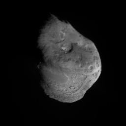
PIA02142: Tempel 1 Composite Map
 Target Name:  Tempel 1
 Is a satellite of:  Sol (our sun)
 Mission:  Deep Impact
 Spacecraft:  Deep Impact
 Instrument:  Impactor Targeting Sensor (ITS)
 Product Size:  2048 x 2048 pixels (w x h)
 Produced By:  University of Maryland
 Producer ID:  2005-143
 Full-Res TIFF:  PIA02142.tif (4.199 MB)
 Full-Res JPEG:  PIA02142.jpg (121.6 kB)

Click on the image above to download a moderately sized image in JPEG format (possibly reduced in size from original)

Original Caption Released with Image:

Annotated image of Tempel 1 Composite Map
Annotated image of
Tempel 1 Composite Map

This composite image was built up from scaling all images to 5 meters/pixel, and aligning images to fixed points. Each image at closer range, replaced equivalent locations observed at a greater distance. The impact site has the highest resolution because images were acquired until about 4 sec from impact or a few meters from the surface.

Arrows a and b point to large, smooth regions. The impact site is indicated by the third large arrow. Small arrows highlight a scarp that is bright due to illumination angle, which shows the smooth area to be elevated above the extremely rough terrain. The scale bar is 1 km and the two arrows above the nucleus point to the sun and the rotational axis of the nucleus. Celestial north is near the rotational pole.

Image Credit:
NASA/JPL/UMD

Image Addition Date:
2005-09-06