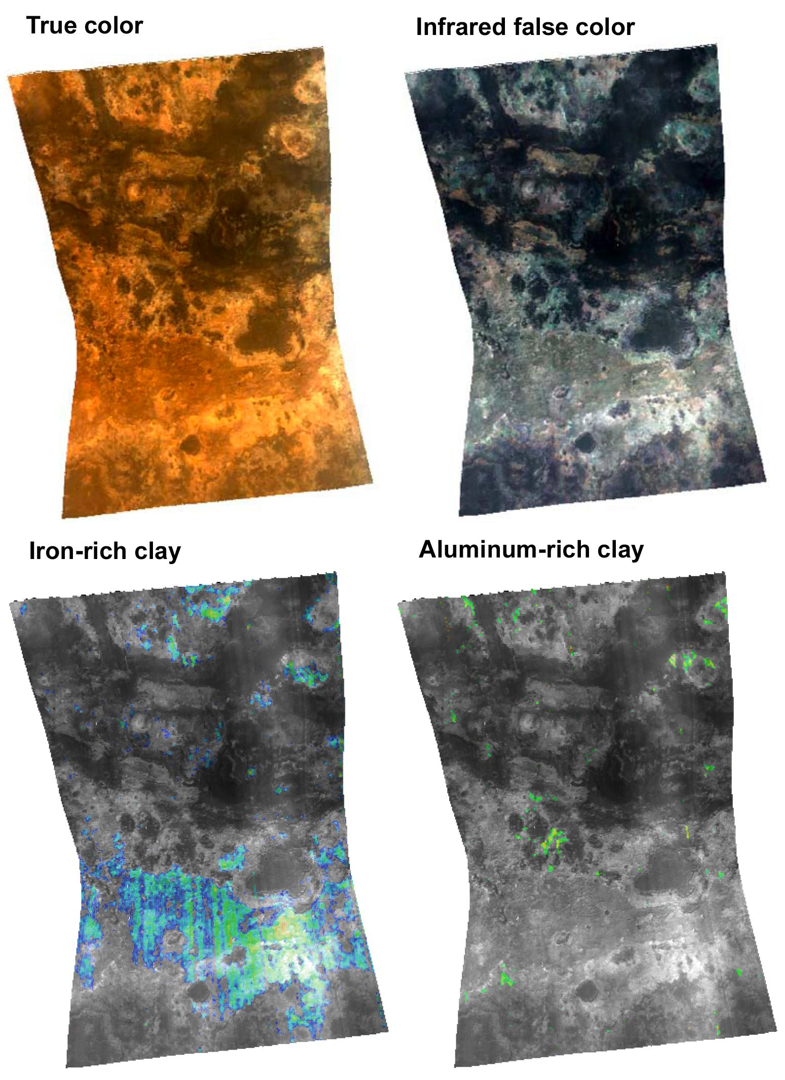
This targeted image from the Compact Reconnaissance Imaging Spectrometer for Mars (CRISM) shows a region of heavily altered rock in Mars' ancient cratered highlands. The featured region is just south of Mawrth Vallis, a channel cut by floodwaters deep into the highlands.
CRISM acquired the image at 1216 UTC (8:16 a.m. EDT) on Oct. 2, 2006, near 25.4 degrees north latitude, 340.7 degrees east longitude. It covers an area about 13 kilometers (8 miles) long and, at the narrowest point, about 9 kilometers (5.6 miles) wide. At the center of the image, the spatial resolution is as good as 35 meters (115 feet) per pixel. The image was taken in 544 colors covering 0.36-3.92 micrometers.
This image includes four renderings of the data, all map-projected. At top left is an approximately true-color representation. At top right is false color showing brightness of the surface at selected infrared wavelengths. In the two bottom views, brightness of the surface at different infrared wavelengths has been compared to laboratory measurements of minerals, and regions that match different minerals have been colored. The bottom left image shows areas high in iron-rich clay, and the bottom right image shows areas high in aluminum-rich clay.
Clay minerals are important to understanding the history of water on Mars because their formation requires that rocks were exposed to liquid water for a long time. Environments where they form include soils, cold springs, and hot springs. There are many clay minerals, and which ones form depends on the composition of the rock, and the temperature, acidity, and salt content of the water. CRISM's sister instrument on the Mars Express spacecraft, OMEGA, has spectrally mapped Mars at lower spatial resolution and found several regions rich in clay minerals. The Mawrth Vallis region, in particular, was found to contain iron-rich clay. CRISM is observing these regions at several tens of times higher spatial resolution, to correlate the minerals with different rock formations and to search for new minerals not resolved by OMEGA.
CRISM has found that the iron-rich clays (lower left image) correspond with a layer of rock that is dark red in the true color view (upper left) and bright gray in the infrared (upper right). In addition, it has found previously undetected exposures of aluminum-rich clay, in a rock unit that is buff-colored in the true color view, and bluish in the infrared. Both types of rocks formed early in Mars' history, about 3.8 billion years ago. The difference in clay mineralogy reveals differences in the environment either over time or over a distance of kilometers. CRISM will be taking many more images of the Mawrth Vallis region to piece together the geologic history of this fascinating area that was once a wet oasis on Mars.
The Compact Reconnaissance Imaging Spectrometer for Mars (CRISM) is one of six science instruments on NASA's Mars Reconnaissance Orbiter. Led by The Johns Hopkins University Applied Physics Laboratory, the CRISM team includes expertise from universities, government agencies and small businesses in the United States and abroad.
CRISM's mission: Find the spectral fingerprints of aqueous and hydrothermal deposits and map the geology, composition and stratigraphy of surface features. The instrument will also watch the seasonal variations in Martian dust and ice aerosols, and water content in surface materials -- leading to new understanding of the climate.
NASA's Jet Propulsion Laboratory, a division of the Califonia Institute of Technology, Pasadena, manages the Mars Reconnaissance Orbiter for the NASA Science Mission Directorate, Washington. Lockheed Martin Space Systems, Denver, is the prime contractor and built the spacecraft.
