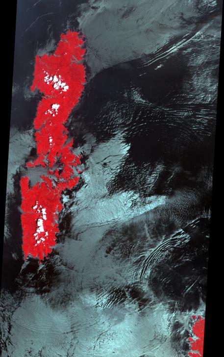
Internal waves are waves that travel within the interior of a fluid. The waves propagate at the interface or boundary between two layers with sharp density differences, such as temperature. They occur wherever strong tides or currents and stratification occur in the neighborhood of irregular topography. They can propagate for several hundred kilometers. The ASTER false-color VNIR image off the island of Tsushima in the Korea Strait shows the signatures of several internal wave packets, indicating a northern propagation direction.
With its 14 spectral bands from the visible to the thermal infrared wavelength region, and its high spatial resolution of 15 to 90 meters (about 50 to 300 feet), ASTER images Earth to map and monitor the changing surface of our planet.
ASTER is one of five Earth-observing instruments launched December 18, 1999, on NASA's Terra satellite. The instrument was built by Japan's Ministry of Economy, Trade and Industry. A joint U.S./Japan science team is responsible for validation and calibration of the instrument and the data products.
The broad spectral coverage and high spectral resolution of ASTER provides scientists in numerous disciplines with critical information for surface mapping, and monitoring of dynamic conditions and temporal change. Example applications are: monitoring glacial advances and retreats; monitoring potentially active volcanoes; identifying crop stress; determining cloud morphology and physical properties; wetlands evaluation; thermal pollution monitoring; coral reef degradation; surface temperature mapping of soils and geology; and measuring surface heat balance.
The U.S. science team is located at NASA's Jet Propulsion Laboratory, Pasadena, Calif. The Terra mission is part of NASA's Science Mission Directorate.
Size: 60 by 120 kilometers (37.2 by 74.4 miles)
Location: 34.6 degrees North latitude, 129.5 degrees East longitude
Orientation: North at top
Image Data: ASTER bands 3, 2, and 1
Original Data Resolution: 90 meters (295 feet)
Dates Acquired: July 4, 2000