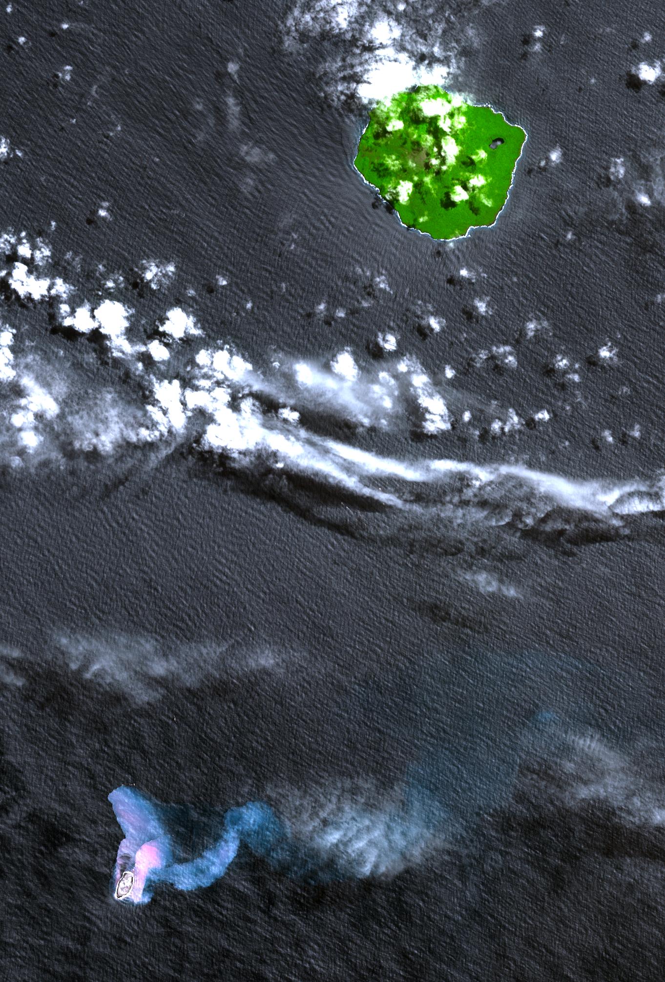
In the South Pacific, south of Late Island along the Tofua volcanic arc in Tonga, a new volcanic island Home Reef is being re-born. The island is thought to have emerged after a volcanic eruption in mid-August that has also spewed large amounts of floating pumice into Tongan waters and sweeping across to Fiji about 350 km (220 miles) to the west of where the new island has formed. In 2004 a similar eruption created an ephemeral island about 0.5 by 1.5 km (0.3 by 0.9 miles) in size; it was no longer visible in an ASTER image acquired November 2005. This simulated natural color image shows the vegetation-covered stratovolcanic island of Late in the upper right. Home Reef is found in the lower left. The two bluish plumes are hot seawater that is laden with volcanic ash and chemicals; the larger one can be traced for more than 14 km (8.4 miles) to the east. The image was acquired October 10, 2006 and covers an area of 24.3 by 30.2 km. It is located at 18.9 degrees South latitude, 174.7 degrees west longitude.
With its 14 spectral bands from the visible to the thermal infrared wavelength region, and its high spatial resolution of 15 to 90 meters (about 50 to 300 feet), ASTER images Earth to map and monitor the changing surface of our planet.
ASTER is one of five Earth-observing instruments launched December 18, 1999, on NASA's Terra satellite. The instrument was built by Japan's Ministry of Economy, Trade and Industry. A joint U.S./Japan science team is responsible for validation and calibration of the instrument and the data products.
The broad spectral coverage and high spectral resolution of ASTER provides scientists in numerous disciplines with critical information for surface mapping, and monitoring of dynamic conditions and temporal change. Example applications are: monitoring glacial advances and retreats; monitoring potentially active volcanoes; identifying crop stress; determining cloud morphology and physical properties; wetlands evaluation; thermal pollution monitoring; coral reef degradation; surface temperature mapping of soils and geology; and measuring surface heat balance.
The U.S. science team is located at NASA's Jet Propulsion Laboratory, Pasadena, Calif. The Terra mission is part of NASA's Science Mission Directorate.
Size: 24.3 by 30.2 kilometers (15 by 18.6 miles)
Location: 18.9 degrees South latitude, 174.7 degrees West longitude
Orientation: North at top
Image Data: ASTER bands 3, 2, and 1
Original Data Resolution: 15 meters (49.2 feet)
Dates Acquired: October 4, 2006
 Planetary Data System


