Annotated Version
 |  |  |
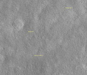
| Viking 2 Back Shell | Viking 2 Heat Shield | Viking 2 Lander |
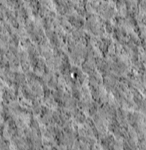
NASA's Viking Lander 2 landed on Mars on Sept. 3, 1976, in Utopia Planitia. The lander, which has a diameter of about 3 meters (10 feet), has been precisely located in this image from the High Resolution Imaging Science Experiment on NASA's Mars Reconnaissance Orbiter. Also, likely locations have been found for the heat shield and back shell. The lander location has been confirmed by overlaying the lander-derived topographic contours on the high-resolution camera's image, which provides an excellent match. Viking Lander 2 was one element of an ambitious mission to study Mars, with a four-spacecraft flotilla consisting of two orbiters and two landers. Four cutouts from this image are shown. The first is an overview showing the relative locations of the lander and candidate back shell and heat shield, and the others are enlargements of each of these components. Large boulders, dunes, and other features visible in Viking Lander 2 images can be located in the high-resolution camera's image. The polygonal pattern of the surface is typical at these latitudes and may be due to the presence of deep subsurface ice.
As chance would have it, this image is blurred in some places due to the abrupt motion associated with the restart of the orbiter's high-gain antenna tracking during the very short image exposure. This is the first time after acquiring hundreds of pictures that a High Resolution Imaging Science Experiment image has been unintentionally smeared; overall performance has been excellent.
A prime motivation for early viewing of the Viking sites is to calibrate imagery taken from orbit with the data previously acquired by the landers. In particular, determining what sizes of rocks can be seen from Mars Reconnaissance Orbiter aids the interpretation of data now being taken to characterize sites for future landers, such as the Phoenix Mars Lander mission to be launched in 2007.
Images from the High Resolution Imaging Science Experiment and additional information about the Mars Reconnaissance Orbiter are available online at: http://www.nasa.gov/mro or http://HiRISE.lpl.arizona.edu.
For information about NASA and agency programs on the Web, http://www.nasa.gov.
NASA's Jet Propulsion Laboratory, a division of the California Institute of Technology in Pasadena, manages the Mars Reconnaissance Orbiter for NASA's Science Mission Directorate, Washington. Lockheed Martin Space Systems is the prime contractor for the project and built the spacecraft. The High Resolution Imaging Science Experiment camera was built by Ball Aerospace Corporation and is operated by the University of Arizona.


