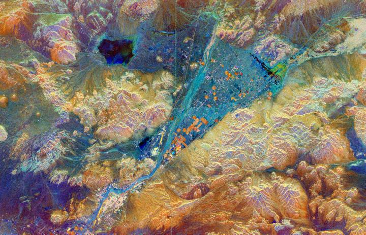
This spaceborne radar image shows part of the Mojave Desert in the vicinity of Barstow, California and reveals evidence of human activities in the arid environment of the southern California deserts. The city of Barstow is the pinkish area in the lower left center. The V-shaped blue area in the center of the image is the Manix Basin, which includes the bed of the Mojave River. Two major transportation corridors mark the sides of the "V." Major railways (bright lines) and interstate highways (darker parallel lines) follow these corridors. The famous U.S. Highway ("Route") 66 follows the southern corridor, from Barstow to the upper right corner. The orange circular and rectangular patches within the basin are irrigated agricultural fields. Radar data have been used to evaluate the effects of irrigation practices on soil stability and land degradation in this desert region. Sparsely vegetated areas of sand and small gravel appear blue in this image, while rocky hills and rougher gravel deposits appear mostly in shades of orange and brown. The dark patch in the upper left is the very smooth surface of Coyote Dry Lake. A line of bright dots running from the top of the image to the center is a set of electrical power line towers. Variations in color on the hills on the left side of the image are caused by difference in surface roughness related to rock composition. This image was acquired by Spaceborne Imaging Radar-C/X-Band Synthetic Aperture Radar (SIR-C/X-SAR) onboard the space shuttle Endeavour on April 12, 1994. The image is 75 kilometers by 48 kilometers (46 miles by 30 miles) and is centered at 34.9 degrees North latitude, 116.8 degrees West longitude. North is toward the upper left. The colors are assigned to different radar frequencies and polarizations of the radar as follows: red is C-band, horizontally transmitted, vertically received; green is L-band, horizontally transmitted and received; and blue is the ratio of C-band to L-band, both horizontally transmitted and received.
Spaceborne Imaging Radar-C and X-band Synthetic Aperture Radar (SIR-C/X-SAR) is part of NASA's Mission to Planet Earth. The radars illuminate Earth with microwaves, allowing detailed observations at any time, regardless of weather or sunlight conditions. SIR-C/X-SAR uses three microwave wavelengths: L-band (24 cm), C-band (6 cm) and X-band (3 cm). The multi-frequency data will be used by the international scientific community to better understand the global environment and how it is changing. The SIR-C/X-SAR data, complemented by aircraft and ground studies, will give scientists clearer insights into those environmental changes which are caused by nature and those changes which are induced by human activity.
SIR-C was developed by NASA's Jet Propulsion Laboratory. X-SAR was developed by the Dornier and Alenia Spazio companies for the German space agency, Deutsche Agentur fuer Raumfahrtangelegenheiten (DARA), and the Italian space agency, Agenzia Spaziale Italiana (ASI), with the Deutsche Forschungsanstalt fuer Luft und Raumfahrt e.V.(DLR), the major partner in science, operations and data processing of X-SAR.