PDS logoPlanetary Data System
PDS Information
Find a Node - Use these links to navigate to any of the 8 publicly accessible PDS Nodes.

This bar indicates that you are within the PDS enterprise which includes 6 science discipline nodes and 2 support nodes which are overseen by the Project Management Office at NASA's Goddard Space Flight Center (GSFC). Each node is led by an expert in the subject discipline, supported by an advisory group of other practitioners of that discipline, and subject to selection and approval under a regular NASA Research Announcement.
Click here to return to the Photojournal Home Page Click here to view a list of Photojournal Image Galleries Photojournal_inner_header
Latest Images  |  Spacecraft & Technology  |  Animations  |  Space Images App  |  Feedback  |  Photojournal Search  

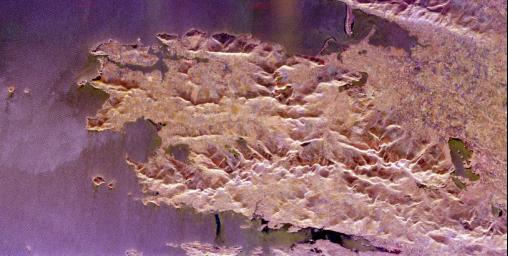
PIA01848: Space Radar Image of County Kerry, Ireland
 Target Name:  Earth
 Is a satellite of:  Sol (our sun)
 Mission:  Spaceborne Imaging Radar-C/X-Band Synthetic Aperture Radar 
 Spacecraft:  Space Shuttle
 Product Size:  3295 x 1662 pixels (w x h)
 Produced By:  JPL
 Producer ID:  P47123
 Addition Date:  1999-04-15
 Full-Res TIFF:  PIA01848.tif (18.29 MB)
 Full-Res JPEG:  PIA01848.jpg (1.841 MB)

Click on the image above to download a moderately sized image in JPEG format (possibly reduced in size from original)

Original Caption Released with Image:

The Iveragh Peninsula, one of the four peninsulas in southwestern Ireland, is shown in this spaceborne radar image. The lakes of Killarney National Park are the green patches on the left side of the image. The mountains to the right of the lakes include the highest peaks (1,036 meters or 3,400 feet) in Ireland. The patchwork patterns between the mountains are areas of farming and grazing. The delicate patterns in the water are caused by refraction of ocean waves around the peninsula edges and islands, including Skellig Rocks at the right edge of the image. The Skelligs are home to a 15th century monastery and flocks of puffins. The region is part of County Kerry and includes a road called the "Ring of Kerry" that is one of the most famous tourist routes in Ireland.

This image was acquired by the Spaceborne Imaging Radar-C/X-band Synthetic Aperture Radar (SIR-C/X-SAR) onboard the Space Shuttle Endeavour on April 12, 1994. The image is 82 kilometers by 42 kilometers (51 miles by 26 miles) and is centered at 52.0 degrees north latitude, 9.9 degrees west longitude. North is toward the lower left. The colors are assigned to different radar frequencies and polarizations of the radar as follows: red is L-band, horizontally transmitted and received; green is L-band, vertically transmitted and received; and blue is C-band, vertically transmitted and received. SIR-C/X-SAR, a joint mission of the German, Italian and United States space agencies, is part of NASA's Mission to Planet Earth program.

Image Credit:
NASA/JPL

Image Addition Date:
1999-04-15