- Original Caption Released with Image:
-
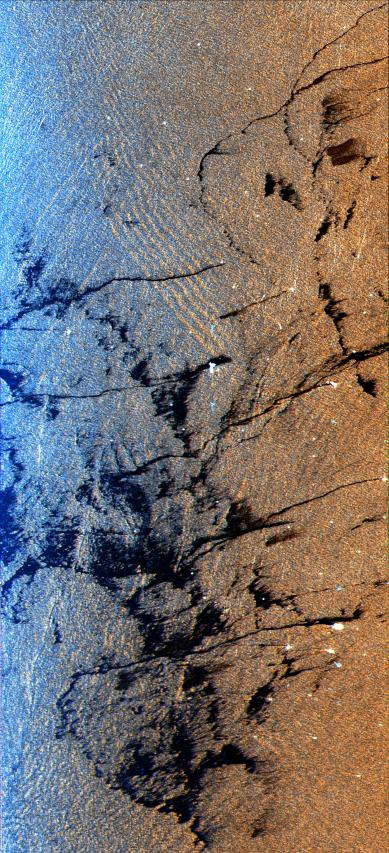
This is a radar image of an offshore drilling field about 150 km (93 miles) west of Bombay, India, in the Arabian Sea. The dark streaks are extensive oil slicks surrounding many of the drilling platforms, which appear as bright white spots. Radar images are useful for detecting and measuring the extent of oil seepages on the ocean surface, from both natural and industrial sources. The long, thin streaks extending from many of the platforms are spreading across the sea surface, pushed by local winds. The larger dark patches are dispersed slicks that were likely discharged earlier than the longer streaks, when the winds were probably from a different direction. The dispersed oil will eventually spread out over the more dense water and become a layer which is a single molecule thick. Many forms of oil, both from biological and from petroleum sources, smooth out the ocean surface, causing the area to appear dark in radar images. There are also two forms of ocean waves shown in this image. The dominant group of large waves (upper center) are called internal waves. These waves are formed below the ocean surface at the boundary between layers of warm and cold water and they appear in the radar image because of the way they change the ocean surface. Ocean swells, which are waves generated by winds, are shown throughout the image but are most distinct in the blue area adjacent to the internal waves. Identification of waves provide oceanographers with information about the smaller scale dynamic processes of the ocean.
This image was acquired by the Spaceborne Imaging Radar-C/X-Band Synthetic Aperture Radar (SIR-C/X-SAR) aboard the space shuttle Endeavour on October 9, 1994. The colors are assigned to different frequencies and polarizations of the radar as follows: Red is L-band vertically transmitted, vertically received; green is the average of L-band vertically transmitted, vertically received and C-band vertically transmitted, vertically received; blue is C-band vertically transmitted, vertically received. The image is located at 19.25 degrees north latitude and 71.34 degrees east longitude and covers an area 20 km by 45 km (12.4 miles by 27.9 miles). SIR-C/X-SAR, a joint mission of the German, Italian and United States space agencies, is part of NASA's Mission to Planet Earth.
- Image Credit:
-
NASA/JPL
Image Addition Date: -
1999-04-15
|