- Original Caption Released with Image:
-
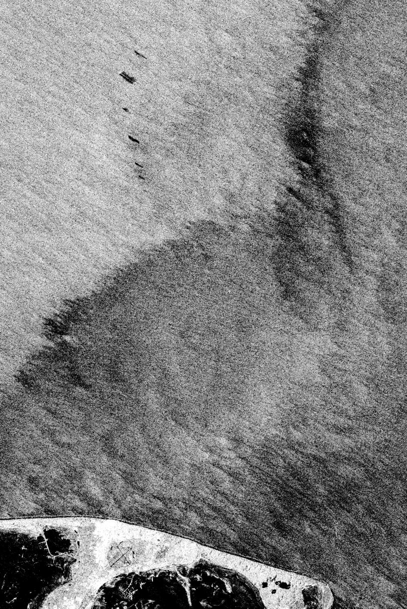
This is an X-band image of an oil slick experiment conducted in the North Sea, Germany. The image is centered at 54.58 degrees north latitude and 7.48 degrees east longitude. This image was acquired by the Spaceborne Imaging Radar-C and X-band Synthetic Aperture Radar (SIR-C/X-SAR) aboard the space shuttle Endeavour on October 6, 1994, during the second flight of the spaceborne radar.
The experiment was designed to differentiate between petroleum oil spills and natural slicks floating on the sea surface. Two types of petroleum oil and six types of oils resembling natural sea surface slicks were poured on the sea surface from ships and a helicopter just before the space shuttle flew over the region. At the bottom of the image is the Sylt peninsula, a famous holiday resort. Twenty-six gallons (100 liters) of diesel oil was dissipated due to wave action before the shuttle reached the site. The oil spill seen at the uppermost part of the image is about 105 gallons (400 liters) of heavy heating oil and the largest spill is about 58 gallons (220 liters) of oleyl alcohol, resembling a "natural oil" like the remaining five spills used to imitate natural slicks that have occurred offshore from various states. The volume of these other oils spilled on the ocean surface during the five experimental spills varied from 16 gallons to 21 gallons (60 liters to 80 liters). The distance between neighboring spills was about half a mile (800 meters) at the most. The largest slick later thinned out to monomolecular sheets of about 10 microns, which is the dimension of a molecule.
Oceanographers found that SIR-C/X-SAR was able to clearly distinguish the oil slicks from algae products dumped nearby. Preliminary indications are that various types of slicks may be distinguished, especially when other radar wavelengths are included in the analysis. Radar imaging of the world's oceans on a continuing basis may allow oceanographers in the future to detect and clean up oil spills much more swiftly than is currently possible.
Spaceborne Imaging Radar-C and X-band Synthetic Aperture Radar (SIR-C/X-SAR) is part of NASA's Mission to Planet Earth. The radars illuminate Earth with microwaves, allowing detailed observations at any time, regardless of weather or sunlight conditions. SIR-C/X-SAR uses three microwave wavelengths: L-band (24 cm), C-band (6 cm) and X-band (3 cm). The multi-frequency data will be used by the international scientific community to better understand the global environment and how it is changing. The SIR-C/X-SAR data, complemented by aircraft and ground studies, will give scientists clearer insights into those environmental changes which are caused by nature and those changes which are induced by human activity.
SIR-C was developed by NASA's Jet Propulsion Laboratory. X-SAR was developed by the Dornier and Alenia Spazio companies for the German space agency, Deutsche Agentur fuer Raumfahrtangelegenheiten (DARA), and the Italian space agency, Agenzia Spaziale Italiana (ASI), with the Deutsche Forschungsanstalt fuer Luft und Raumfahrt e.V.(DLR), the major partner in science, operations and data processing of X-SAR.
- Image Credit:
-
NASA/JPL
Image Addition Date: -
1999-05-01
|