Spring has come to the martian northern hemisphere. The northern spring season began in mid-July 1998. With the arrival of spring comes the annual shrinkage of the north polar frost cap. Sunlight is now falling on the north polar cap, and all of the carbon dioxide frost and snow that accumulated during winter has been sublimating--going directly from solid to gas--and the surface beneath the frost is being revealed.
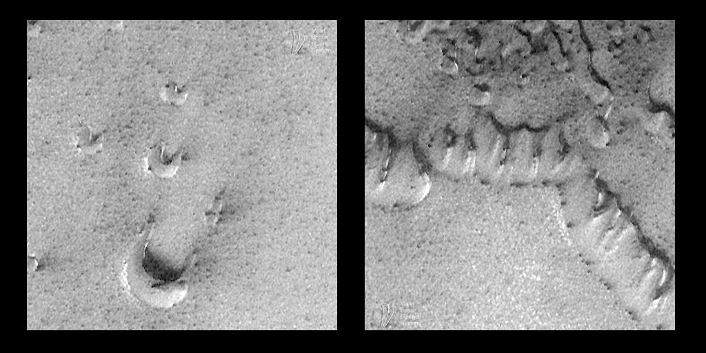
The MOC image shown above, 45205, was obtained during the 452nd orbit of Mars Global Surveyor at 3:10 p.m. PDT on July 26, 1998. The image is located near latitude 76.87°N, longitude 253.81°W, and it shows a close-up view of martian sand dunes. These dunes were not visible to MOC until the last week of July. Just a few months earlier, the dunes were likely covered with frost, obscured by thick clouds, and cloaked by the darkness of the martian polar winter. Indeed, small patches of bright frost were still present when the picture was taken (e.g., the bright patches on the west (left) side of each crescentic dune in (left image).
As the above picture illustrates, the camera on board Mars Global Surveyor (MOC) continued to take exciting new views of the martian surface throughout July 1998. As the month progressed, the ground track-- the area visible to the camera--migrated farther north. Simultaneously, sunlight began falling on the north polar regions, making it possible to take some pictures at far northern latitudes. However, these regions have been tricky to photograph because of thick clouds and hazes. The image shown here, for example, is relatively bland gray (has relatively low contrast) because of clouds.
As first seen by the Viking 2 Orbiter in 1976, a vast "sea" of sand dunes surrounds the north polar cap. The dunes imaged by MOC (above) are classic forms known as barchan dunes--the small, crescent-shaped hills (see left image above)-- and transverse dunes--ridges that resemble coalesced barchans (shown in right image above). These dunes are similar in size and shape to familiar sand dunes found in desert regions on Earth. These two varieties form from winds that persistently come from a single direction (in this case, from the southwest).
Over the next several months, the sky above these dunes will clear. Northern Summer will arrive near the end of January 1999, and Mars Global Surveyor should have an excellent view of this region when it begins its mapping mission in late March 1999. Because it is in a polar orbit, Mars Global Surveyor will have many opportunities to revisit the north polar dunes in 1999. The images in 1999 will have resolutions around 1.5 meters (5 feet) per pixel--a substantial improvement even over the pictures shown here.
