Born in the Atlantic, Hurricane Frances became a category 4 hurricane on August 31, 2004. Expectations are the hurricane will hit the Space Coast of Florida in Brevard County early Sunday morning.
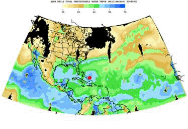
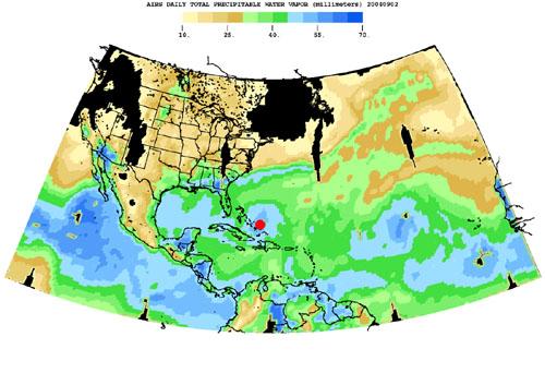
This movie is a time-series of maps that show AIRS observations of the total amount of water vapor present in the atmospheric column above each point of the Earth's surface. If all the water vapor in the column were forced to fall as rain, the depth of the resulting puddle on the surface at that point is equal to the value shown on the map. Fifty millimeters (mm) is about 2 inches. The large band of maximum water vapor in the neighborhood of the equator is the Intertropical Convergence Zone (ITCZ), a region of strong convection and powerful thunderstorms.
This movie shows the total precipitable water vapor from August 23 through September 2, 2004. You can see Hurricane Frances as it moves through the Caribbean toward Florida, and the changes in intensity are visible. The eye has been marked with a red spot. The water vapor encompassed by the hurricane is also the result of the very strong convection which is an integral part of the formation and intensification of tropical storms. If you look at the last frame of the movie in the lower right corner, you can see the emergence of a new tropical storm. Ivan makes its debut in the Atlantic.
About AIRS
The Atmospheric Infrared Sounder, AIRS, in conjunction with the Advanced Microwave Sounding Unit, AMSU, senses emitted infrared and microwave radiation from Earth to provide a three-dimensional look at Earth's weather and climate. Working in tandem, the two instruments make simultaneous observations all the way down to Earth's surface, even in the presence of heavy clouds. With more than 2,000 channels sensing different regions of the atmosphere, the system creates a global, three-dimensional map of atmospheric temperature and humidity, cloud amounts and heights, greenhouse gas concentrations, and many other atmospheric phenomena. Launched into Earth orbit in 2002, the AIRS and AMSU instruments fly onboard NASA's Aqua spacecraft and are managed by NASA's Jet Propulsion Laboratory in Pasadena, Calif., under contract to NASA. JPL is a division of the California Institute of Technology in Pasadena.
More information about AIRS can be found at http://airs.jpl.nasa.gov.