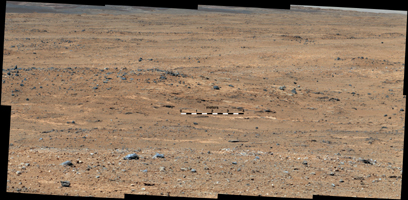
Figure 1
Click on the image for larger versionAn outcrop visible as light-toned streaks in the lower center of this image has been chosen as a place for NASA's Mars rover Curiosity to study for a few days in September 2013. The pause for observations at this area, called "Waypoint 1," is the first during the rover's trek of many months from the "Glenelg" area where it worked for the first half of 2013 to an entry point to the lower layers of Mount Sharp. This pale outcrop is informally named "Darwin."
The view is a mosaic of images taken by the telephoto-lens camera of the Mast Camera (Mastcam) on Curiosity during the 387th Martian day, or sol, of Curiosity's work on Mars (Sept. 7, 2013). The rover's position was on a rise called "Panorama Point," and the view looks southwestward. The Sol 387 position was at the endpoint of the mission's longest-yet drive, 464 feet or 141.5 meters on Sol 385, and before a Sol 388 drive to the top of the rise.
Colors in the image have been white-balanced, showing what the rocks would look like if they were under Earth's sky. Figure 1 includes a 4-meter scale bar (13 feet) to indicate the size of features in the Darwin area.
Waypoint 1 is the first of a few waypoint stops planned along the route to the Mount Sharp entry point. Studies at these waypoints are intended to help researchers trace how the rocks at Glenelg, where the mission found evidence of an ancient habitable environment, are related to the lower layers of Mount Sharp, where scientists hope to learn more about habitable environments and major changes in environmental conditions.
Curiosity finished more than six months of investigations in the Glenelg area in early July 2013 and began the drive of about 5.3 miles (8.6 kilometers) from Glenelg to the Mount Sharp entry point. Waypoint 1 is about one-fifth of the way along the route plotted with the use of images taken from orbit.
Malin Space Science Systems, San Diego, built and operates Mastcam. NASA's Jet Propulsion Laboratory manages the Mars Science Laboratory mission and the mission's Curiosity rover for NASA's Science Mission Directorate in Washington. The rover was designed, developed and assembled at JPL, a division of the California Institute of Technology in Pasadena.
For more about NASA's Curiosity mission, visit http://www.jpl.nasa.gov/msl, http://www.nasa.gov/mars, and http://marsprogram.jpl.nasa.gov/msl.
