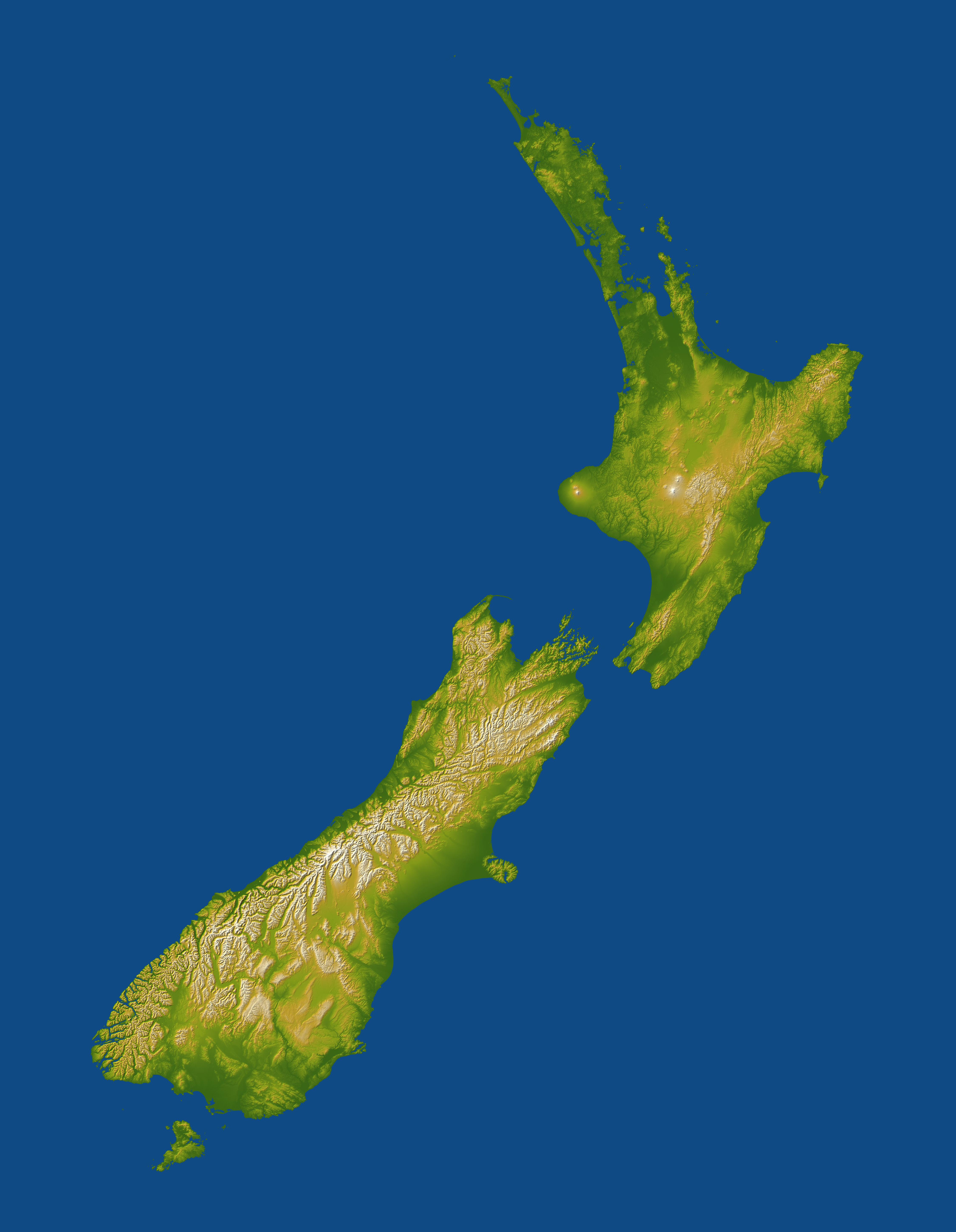
New Zealand straddles the juncture of the Indo-Australian and Pacific tectonic plates, two of Earth's major crustal plates. The two plates generally converge in subduction zones, but in a scissor-like pattern, with the Indo-Austalian plate overriding the Pacific plate to the north and the Pacific plate overriding the Indo-Australian plate to the south. New Zealand is "what happens" in between at and near the cross point of this scissor pattern. Here the convergence has built two major islands that together exhibit very active volcanoes and fault systems, and these geologic features are very evident in the topographic pattern.
The North Island lies at the southern end of the west-over-east (Indo-Australian over Pacific) plate convergence. The Pacific plate dives under the North Island and this subduction process leads to melting of rocks at depth, the rise of magma to the surface, and the formation of volcanoes and other geothermal features. Most notable are Mount Taranaki on the west coast, and Mounts Ruapehu, Ngauruhoe, and Tongariro just south of the island's centerpoint, all of which are shown with white peaks in this display. The Rotorua geothermal field occurs further northeast and is evident here as a scattering of comparatively small bumps created by smaller volcanic eruptions.
The South Island straddles the cross point of the subduction scissor pattern and prominently features a fault system that connects the two subduction zones. (The east-over-west (Pacific over Indo-Australian) plate convergence generally occurs south of the South Island.) The Alpine fault is the major strand of this fault system along most of the length of the island, near and generally paralleling the west coast. Its impact upon the topography is unmistakable, forming an extremely sharp and straight northwest boundary to New Zealand's tallest mountains, the Southern Alps. Although offsets on the Alpine fault are generally right-lateral (35-40 millimeters per year) and thus consistent with the offset in the subduction zone pattern, vertical offsets (about 7 millimeters per year) are likewise consistent with the uplift of the Southern Alps.
Two visualization methods were combined to produce this image: shading and color coding of topographic height. The shade image was derived by computing topographic slope in the northwest-southeast direction, so that northwest slopes appear bright and southeast slopes appear dark. Color coding is directly related to topographic height, with green at the lower elevations, rising through yellow and tan, to white at the highest elevations.
Elevation data used in this image were acquired by the Shuttle Radar Topography Mission aboard the Space Shuttle Endeavour, launched on Feb. 11, 2000. SRTM used the same radar instrument that comprised the Spaceborne Imaging Radar-C/X-Band Synthetic Aperture Radar (SIR-C/X-SAR) that flew twice on the Space Shuttle Endeavour in 1994. SRTM was designed to collect 3-D measurements of the Earth's surface. To collect the 3-D data, engineers added a 60-meter (approximately 200-foot) mast, installed additional C-band and X-band antennas, and improved tracking and navigation devices. The mission is a cooperative project between NASA, the National Geospatial-Intelligence Agency (NGA) of the U.S. Department of Defense and the German and Italian space agencies. It is managed by NASA's Jet Propulsion Laboratory, Pasadena, Calif., for NASA's Earth Science Enterprise, Washington, D.C.
Location: 33.5 to 48 degrees South latitude, 165 to 180 degrees East longitude
Orientation: North toward the top, cylindrical projection
Image Data: Shaded and colored SRTM elevation model
Date Acquired: February 2000
